Never heard of USArray? Neither had I until this morning.
USArray is a 15-year old program that places networks of seismographs across the United States that record local, regional and distant earthquakes. Using data from historical “geological hazards” (earthquakes, volcanoes, landslides, etc.) and analyzing continental fault lines, the program works to determine the most earthquake-prone areas.
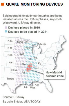
The project, which involves a traveling network of 400 high-quality, portable seismographs placed in temporary sites, will reach the halfway mark this summer in its goal to measure upheavals beneath the earth’s surface from California to Maine, says project director Bob Woodward.
The findings will give scientists a more detailed picture in regards to earthquake activity in the U.S.,  especially in the Pacific Northwest, an area that has experienced considerable seismic activity within the last several years. The information gathered will not only help scientists understand earthquakes, but will also educate residents of those areas about the dangers of such a catastrophe and could also lead to stricter building codes in such places.
Though earthquakes occur most along the West coast, they are also a common occurrence along the New Madrid seismic zone, an area named after New Madrid, Missouri, where a series of massive earthquakes occurred in 1811 and 1812.
But what if an earthquake were to hit the Northeast? A January 14th Congressional Service Report addressed that question.
The report states that there could be approximately $900 billion in damages, including, “damage to the heavily populated central New Jersey-Philadelphia corridor if a 6.5-magnitude earthquake occurred along a fault lying between New York City and Philadelphia.”
The USArray project involves a traveling network of 400 portable seismographs that started on the West Coast and is currently moving east.
Before the instruments were installed, “it was kind of like taking a picture with a camera with only a few pixels,” Woodward says. “With 400 stations out there, it’s like having a much higher resolution camera.
buy renova online https://hunterdonradiology.com/wp-content/uploads/2023/10/jpg/renova.html no prescription pharmacySo now you can directly see the seismic waves rolling across the country.”
The costliest earthquake in the world (measured by insured losses) was the January 17th, 1994 Northridge, California earthquake, which totaled $15.3 million. With those kind of numbers, any tool to help scientists and society better understand, and possibly predict, earthquakes is invaluable.
