Для тех, кто интересуется безопасным доступом к онлайн-играм, наш партнер предлагает зеркало Вавады, которое позволяет обходить любые блокировки и сохранять доступ ко всем функциям казино.

Texas Study Shows Business Impact of Major Storms

A new study conducted by Texas A&M University at Galveston and the Texas General Land Office examines the 50-year impact of a major storm hitting Galveston Bay on the Texas coast near Houston, including secondary effects to the economy. The study focused on catastrophic “500-year” flood events (with a one-in-500 chance of occurring in a year), which, while rare, have hit the state 3 times in recent years. This includes Hurricane Harvey, which struck Louisiana and Texas in August 2017, causing $125 billion in damage, according to the National Hurricane Center.

These larger storms have serious economic impacts locally, regionally and nationally. Over a 50-year time frame, the study notes, “the projected economic impact on Texas’ Gross State Product (GSP) of storm surge without coastal protection is substantial.” In the wake of a 500-year magnitude event, the regional petroleum and chemical manufacturing sectors would see their output decline by 19% (or $175.4 billion) in lost revenue, as well as a projected 17% loss of petroleum jobs (approximately 155,000 jobs) and a petroleum price increase of 13%. It would also impact the region’s housing, with the sector declining by 8%, or $39.5 billion lost in sales.

A 500-year surge event striking Galveston Bay would also have serious impacts for national economic activity, especially because the region processes 25% of the petroleum and more than half of the jet fuel used in the United States. According to the study, U.S. GDP could drop 1.1% (approximately $883 billion), U.S. exports would suffer a 4% drop (approximately $1.66 billion) and “30 states not including Texas will have lower GSP in response to a surge event in Texas.”

“The Galveston Bay region is one of the most flood- and surge-prone areas in the United States with vast amounts of vulnerable residential, commercial, industrial and petro-chemical areas at risk,” said Texas Land Commissioner George P. Bush. “This study clearly demonstrates that, without any new protections in place, future storm surges could have substantial and lingering impacts on Texas’ economy and send lasting ripples through other economic sectors nationwide.”

Turning to mitigation, the authors of the report assessed the potential measure of a 17-foot “coastal spine,” also called a “coastal storm suppression system,” made up of “connecting seawalls and fortified dunes/levees along the coastline to retractable gates.” In October, the Army Corps of Engineers released the study Coastal Texas Protection and Restoration Feasibility Study proposing a similar example of this sort of structure—74 miles of barrier, including “floodwalls (inverted T-walls), floodgates (both highway and railroad floodgates), seawall improvements, drainage structures, pump stations, and surge barrier gates.”

The researchers estimate that a coastal spine would reduce the region’s lost petroleum and chemical manufacturing sector losses to 3% and 5%, respectively, a 1% reduction in regional unemployment, and a 1% increase in petroleum product prices. The report also claims that a coastal spine mitigation plan would reduce Houston-Galveston regional insurance premiums by as much as 28%. This could provide significant relief for insurers as well. Even though insurance and reinsurance only covered about 30% of the total wind and flood damage from Hurricane Harvey, this amounted to tens of millions in losses.

In terms of construction cost, the Texas researchers polled residents of three local counties and found that 56% “believed that both government and port industries should be responsible for financing the coastal barrier system,” and a majority agreed that some form of taxation should support its construction.

Coastal High Tide Flooding Escalates, NOAA Reports

According to the third U.S. National Climate Assessment, “Global climate is changing and this is apparent across the United States in a wide range of observations.” Rising temperatures leading to increasingly high sea levels have changed coastal flood patterns, leading to more frequent high tide flooding, the National Centers for Environmental Information (NOAA) said in its National Climate Report’s 2018 Outlook of coastal flooding.

“As a whole, high tide flood frequencies during 2018 are predicted to be about 60% higher (median value) across U.

buy finasteride online cosmeticdermcenter.com/wp-content/uploads/2023/10/jpg/finasteride.html no prescription pharmacy

S. coastlines as compared to trend values at the start of this century (i.e., year 2000),” NOAA said.
More than one quarter (27) of the 98 U.S. coastal locations examined tied or broke their individual records for high tide flooding in 2017. The NOAA report found that the Southeast Atlantic coast is now experiencing the fastest rate of increase in annual high tide flood days, with more than a 150% increase since 2000 predicted in 2018 at most locations.
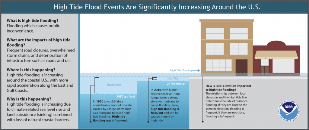
The top five cities that broke records with the highest number of flood days across the United States were: Boston, Massachusetts; Atlantic City, New Jersey; Sandy Hook, New Jersey; Sabine Pass, Texas; and Galveston, Texas. “These cities faced the brunt of an active nor’easter and hurricane seasons and sea level rise, which has made these and other less extreme events more impactful,” NOAA said.

buy mobic online cosmeticdermcenter.com/wp-content/uploads/2023/10/jpg/mobic.html no prescription pharmacy

According to NOAA:

  1. During the 2017 meteorological year (May 2017-April 2018), the U.S. average number of high tide flooding days was the highest measured at 98 NOAA tide gauges. More than a quarter of the coastal locations tied or broke their individual records for high tide flood days.
  2. Water reached a flooding threshold at NOAA tide gauges a record-breaking number of times in the Northeast and the Gulf of Mexico due to a combination of active nor’easter and hurricane seasons combined with sea level rise, making these events more impactful.
  3. The projected increase in high tide flooding in 2018 may be as much as 60% higher across U.S. coastlines as compared to typical flooding about 20 years ago and 100% higher than 30 years ago. This is due to long-term sea level rise trends and, in part, by El Nino conditions that may develop later this year.
    buy tamiflu online cosmeticdermcenter.com/wp-content/uploads/2023/10/jpg/tamiflu.html no prescription pharmacy

Planning for Extreme Floods

Flooding

Companies in the United States should begin preparing now for climate change, which is predicted to cause extreme weather conditions, according to FM Global’s report, The Impact of Climate Change on Extreme Precipitation and Flooding. As the climate warms, areas that are dry will become drier and moist areas will see higher precipitation. The characteristics of precipitation will also change. “We feel cli­mate change not so much through subtle changes in the mean, but through changes in the extremes,” MIT Prof.

online pharmacy lasix with best prices today in the USA

Kerry Emanuel said in the report.

While the overall amount of precipitation might remain the same, it will become less frequent but more intense.

online pharmacy prograf with best prices today in the USA

A specific region of the country that has historically seen 10 inches of rain each May might see the same volume that month, for example, but those 10 inches may occur in a much shorter period of time, increasing the risk of flooding, according to the study.

By the end of the century, as temperatures rise, it is possible for precipitation to change by 8%, which could exacerbate wildfires in some areas and flooding in others.

online pharmacy tretiva with best prices today in the USA

The danger is that, because these extreme events are infrequent, they lack urgency, so planning can easily be put off. Risk managers are advised to check their facility’s resilience in terms of the building’s ability to withstand flooding, focusing on 500-year flood levels rather than 100-year.

Extreme wet or dry conditions can affect a company’s buildings, machinery, data centers, transportation networks, supply chains, people and sales. Organizations should focus on water management—diverting water from property, optimizing drainage and protecting water supplies, and they should consider new weather extremes when managing supply chains.

Flood hazard mapping is increasingly proving helpful as understanding of water risk is improving, Louis Gritzo, vice president and manager of research with FM Global, wrote in “Mitigating Evolving Water Threats,” from this month’s Risk Management Magazine. Advances in technology have led to improvements in weather satellites, geospatial data acquisition and physical model development, making old models obsolete. Anyone working with information from a flood map that is more than 15 years old should consider an update, he wrote.

Those with a flood map should make sure it includes potential coastal flooding areas as well as river flooding, also taking into account the local topography of coastal locations. “Areas along the coast that are surrounded by hills and mountains will likely experience far more wind-blown water (storm surge), as the local terrain directs more water in spaces between steeper slopes,” Gritzo wrote.

Hurricane Katrina Recovery By the Numbers

In anticipation of the 10th anniversary of Hurricane Katrina next week, the Insurance Information Institute collated data on the range of damage it caused, including insurance claims by coverage and state, National Flood Insurance Program losses, and other sources of recovery funds. The costliest hurricane in U.S. history, Katrina killed 1,800 people and cost $125 billion in total economic losses. Such catastrophic losses do not just demonstrate the impact of megadisasters, however.

buy ivermectin online healthymomsandbabes.org/wp-content/uploads/2023/10/jpg/ivermectin.html no prescription pharmacy

As the III points out, while “awareness of flooding due to coastal storms rises, so too does the population of coastal communities.

buy neurontin online healthymomsandbabes.org/wp-content/uploads/2023/10/jpg/neurontin.html no prescription pharmacy

Check out the infographic below for a look at Hurricane Katrina’s total toll and key takeaways:

hurricane katrina damage infographic