LeapWallet is a secure digital wallet that enables easy management of cryptocurrencies. With features like fast transactions and user-friendly interface, it's perfect for both beginners and experts. Check it out at leapwallet.lu.

Unprecedented Wildfires Devastate Canada, Leave Eastern U.S. Blanketed in Smoke

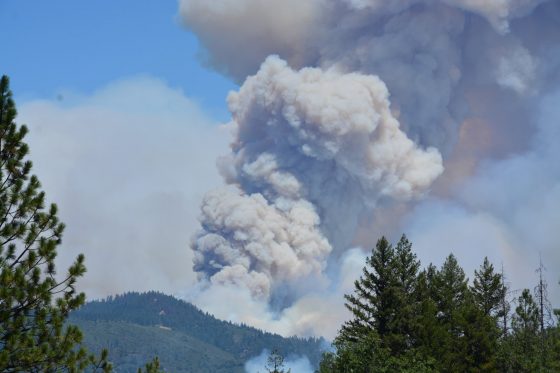
Wildfire season has started two months early in Canada, and the devastating scale of the blazes is already unprecedented. Over 400 fires have caused roughly 10 million acres of burn damage so far, and have blanketed a wide swath of North America in smoke, creating orange skies and toxic levels of air pollution for communities all the way from Canada to the Southeastern United States. During the first week of June, New York had the worst air quality on Earth, and the air quality reached hazardous levels in Philadelphia and Washington, D.C. While it has begun to clear in the Northeast, the fires are ongoing and the air quality may continue to change in the days and weeks to come.

Find more answers to common questions about the wildfires below:

Where is all the smoke coming from?

Unfortunately, there is not just one answer for that, as there are multiple regional fires breaking out seemingly all over Canada and even the United States. However, the current air quality issues are coming from out-of-control wildfires in Quebec and Ottawa, Canada. There are also wildfires breaking out in at least six U.S. states, including Missouri, Kansas and New Mexico, but these do not appear to be involved in the air quality crisis.

According to the Associated Press and Canadian officials, the fires in Canada mark the start of what is expected to be Canada’s worst wildfire season ever due to drier ground than usual, which led the fires to accelerate very quickly.

“Right now, with the manpower we have, we can fight about 40 fires at the same time,” said Francois Legault, premier of Quebec, in an interview with Reuters. “But we have 150 fires, so we have to make sure that we focus where the problems are more urgent.”

In total, there are 425 active fires throughout Canada, according to Canadian Interagency Forest Fire Centre, and 232 are considered out of control. About 120,000 Canadians have been displaced from their homes due to emergency evacuations, with the most recent being from remote parts of Northern Quebec, according to Reuters. There are fires in nearly all of Canada’s provinces. The current wildfires in the U.S. have led to no evacuations thus far.

Why is the U.S. experiencing poor air quality?

To put it simply, the Northeastern region of the U.S. and the rest of the Eastern seaboard as far down as South Carolina are stuck in a slow-moving weather pattern that is carrying the smoke and smell from the Canadian fires southward. According to Politico, 13 U.S. states are under air quality alerts, impacting over 55 million people.

The AP noted that smoke from various Canadian fires has actually been showing up in parts of the U.S. since May, but with new fires recently breaking out in Quebec, the air quality has increasingly gotten worse in both Canada and the U.S. The hazy, orange-tinted skies and smoke smell along the eastern U.S. are expected to dissipate soon but may still be present through the weekend.

How do the fires impact businesses?

The fires affect certain industries more than others. Outdoor work like construction, sporting events, primary schools, park services and zoos are continuing to pay close attention to the air quality and have suspended outdoor operations accordingly while air quality is at such dangerous levels. Many professional sporting events have been cancelled. The New York Yankees, Chicago White Sox, Philadelphia Phillies and Detroit Tigers have postponed baseball games throughout the week, with minor league baseball teams, soccer teams and WNBA teams following their lead.

During the course of the week, airports have been taking various precautions, with JFK, LaGuardia and Newark Liberty International Airport grounding flights, shutting down inbound flights and changing flight schedules. Similar precautions were taken at Philadelphia International Airport. Because this is an ongoing situation, these measures and flight operations remain in flux.

How do we manage the risk?

In terms of immediate action, experts recommend staying indoors, wearing a mask if going outside and keeping windows and doors closed until the air quality alerts are lifted. By the end of the week, New York City’s air quality is expected to be upgraded from “unhealthy” to “unhealthy for sensitive groups.” To find out about your specific area, visit AirNow.gov.

Looking longer-term, the current fires are a good reminder that natural disasters stretch far beyond hurricanes, flooding and tornadoes, especially as the climate continues to change. A recent study found that increases in burned forest area across the western U.S. and southwestern Canada over the last several decades can be linked to significant human-caused climate change.

For businesses, take this as a reminder to examine how your organization will handle fallout from wildfires, for example, reviewing your property insurance, business interruption coverage, disaster recovery plans or emergency communications procedures. The following resources from Risk Management can help organizations consider the many risks wildfires and other climate change-related extreme weather events pose to businesses and communities, and can help boost disaster preparedness for these devastating events.

More resources:

Structures in Wildland Urban Interface Present Added Fire Risks

The trend of building homes in isolated wooded areas has been increasing across the United States. This urbanization of woodlands has changed the way forests are managed. Small wildfires that were once allowed to burn out are now suppressed to protect homes and buildings. Added to this are drought conditions exacerbated by climate change. All of these factors have increased the likelihood of wildfires.

The United States Forest Service (USFS) notes that 32% of the housing units in the U.S. and one-tenth of all land with housing are situated in the Wildland-Urban Interface (WUI). The largest cost driver for both Federal and State wildfire suppression operations is the protection of public and private property in the WUI, according to the USFS.

The “Wildland-Urban Interface Federal Risk Mitigation Executive Order 13728,” released in 2016 by the Federal Emergency Management Agency (FEMA), reported that:

In 2015 alone, more than 10 million acres of wildlands burned, requiring the service of more than 27,000 firefighters and resulting in $2.1 billion spent by the USFS and the Department of the Interior (DOI) to suppress the fires—a record amount. Over the last decade, the fire season has become 2.5 months longer, and fires covering more than 10,000 acres increased, with the average area burned by wildland fires doubling in the last three decades to an estimated seven million acres per year.

This year, more records were broken. In California, the Mendocino Complex Fire became the largest wildfire ever recorded in the state, according to the California Department of Forestry and Fire Protection, or Cal Fire.

According to FEMA, 46 million homes in 70,000 communities are at risk of WUI fires, which have destroyed an average of 3,000 structures annually over the past decade. As more people move into the WUI, businesses follow, putting organizations and jobs at risk.

To protect structures from fire, especially those in the WUI, the Insurance Institute for Business & Home Safety (IBHS) recommends that protection should take into account for a building’s materials and design features—as well as the selection, location and maintenance of landscape plants, including grasses, shrubs, bushes and trees.

According to IBHS, a defensible space should be maintained around a building to reduce wildfire threat and help a building to survive without assistance from firefighters. A vegetation management plan (VMP) also needs to be put in place, particularly in WUI areas. A VMP provides important information about the land, such as:

  • Topography (slope and aspect)
  • Location of building(s) on the land
  • Proposed fuel treatment details (suggested actions such as thinning and prescribed burning to minimize wildfire risks)
  • Environmental concerns (such as threatened and endangered species, state-listed sensitive species and wetlands)

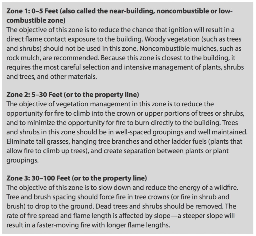
The VMP also provides detailed information on how the three defensible space zones will be developed and maintained. When developing a VMP, IBHS recommends consulting a landscape professional such as a forester, range manager, or natural resource specialist.

IBHS recommends creating three defined areas around a building called defensible space zones. Each zone has specific recommendations for the types of plants used, including how they should be grouped and maintained.

Amid Wildfires, California’s Emergency Warning Systems Take Heat

Overnight, the Mendocino Complex Fire in Northern California expanded far enough to oust the 2017 Thomas Fire as the largest wildfire in the state’s history. Comprising two joined fires, the Mendocino Complex Fire has burned through 443 square miles in the area north of San Francisco. As of Tuesday morning, the fires burned more than 140 structures, including at least 75 homes, and was 30% contained.

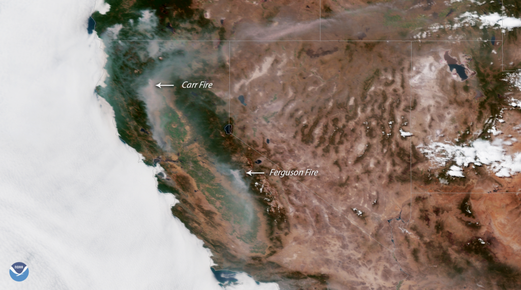
But California’s residents and businesses still should be on alert, as the incendiary activity doesn’t end there. An unprecedented 14,000 firefighters are combating between 12 and 16 wildfires in the state, according to the Department of Forestry and Fire Protection. Particular emphasis is in Northern California, where the fires in Mariposa and Shasta counties continue to threaten residents, businesses, and emergency responders. For 26 days, the Ferguson Fire in Mariposa County has burned nearly 90,000 acres and caused two fatalities. The fire is having a huge impact on areas near and around Yosemite National Park, which alerted the public that it had closed all but two entrances and roads.

Redding, a city 150 miles north of Sacramento, is the site of the Carr Fire, which has been ablaze for two weeks. Weather.com reported that the fire has caused seven deaths and the destruction of nearly 1,600 structures, the majority of which are homes.

The city of Redding launched an interactive map that provides residents with images of neighborhoods so they can check the status of their homes. Reports indicate that more than 1,800 structures are still in the path of the fire.

Despite such technological advances, many residents have questioned the effectiveness of the state’s emergency notification system, which they rely on for evacuation notices.

The California Governor’s Office of Emergency Services currently uses an integrated California Public Alert and Warning System (CalPAWS) Plan to warn the public of danger.

Affected residents in several areas have claimed that they did not receive the CalPAWS evacuation order – including the great-grandmother who perished in the Carr fire in July with her two great-grandchildren. On Aug. 4, California Gov. Jerry Brown held a press conference in Shasta County to discuss the damage. But California’s emergency notification systems—and its unreliability in certain areas of the state—were a central focus of the conference.

Gov. Brown said he would consider legislation to improve alert systems, acknowledging local lawmakers’ proposals in an effort to create a statewide system that requires registration from all residents.

“I think we do need the best alert system we can get, and that’s what I would help the Legislature achieve,” Brown said, according to the Sacramento Bee. “There’s a lot of things we can do, and we can always do more …

given the rising threats on the changing of the weather, the climate.”

The Bee reported that a bill with adoption plans for a uniform alert system has been drafted:

The bill, Senate Bill 833, would require counties to automatically sign up residents for a uniform cell phone alert system. It would also fund a standardized system equipped to push out alerts on all forms of media—radio, television, electronic highway billboards and landlines. County emergency managers would be required to undergo annual training on the latest alert technology.

Under such a plan, which would utilize the federal Wireless Emergency Alerts system, they’d have to opt out rather than sign up voluntarily.

Furthermore, the governor said he hopes to overhaul the state’s 911 system, which would de-centralize the calls and notifications to ensure more accurate messaging.

Also on Aug. 4, the White House approved California’s request for a Presidential Major Disaster Declaration to help with the impacts of the wildfire in Shasta County.

“This is part of a trenda new normalthat we’ve got to deal with. We’re dealing with it humanly, financially and governmentally,” Gov. Brown said during a media briefing at the Carr Fire Incident Command Post in Anderson, California. “These kinds of horrible situations bring people together, regardless of the lesser kind of ideologies and partisan considerations.”

Calif. Carr Fire Claims 6 Lives

Just when it seemed like things couldn’t get any worse in California, the Carr wildfire ignited, claiming six lives so far. The fire in Northern California near the city of Redding has been burning since July 23 and is now one of the largest in the state.

Almost 90,000 acres have burned, destroying more than 500 homes and commercial buildings and damaging 135 structures. Firefighters, who are working 24- to 36-hour shifts with little rest in between, said they are making progress and are now on the offense rather than in a defensive mode.

“Although it’s too early for credible insured loss estimates, the current California wildfires could noticeably impact exposed insurers’ 3Q 2018 earnings,” KBW said in a statement today.

Wildfires are also burning in Mariposa County California. The Ferguson Wildfire has closed large parts of Yosemite National Park, the Risk Management Monitor reported. That fire began July 13 at about 8:30 p.

buy diflucan online achievephysiorehab.ca/wp-content/uploads/2023/10/jpg/diflucan.html no prescription pharmacy

m. and by July 15 had nearly doubled to 9,300 acres. By July 27 it had burned 45,000 acres and was contained 5%, according to NOAA.

buy sinequan online achievephysiorehab.ca/wp-content/uploads/2023/10/jpg/sinequan.html no prescription pharmacy

While authorities have not declared an official cause for that fire, Colin Gannon, senior data analyst at Four Twenty Seven, which studies the economic risk of climate change, said weather and environmental conditions are certainly contributing factors.

The Associated Press reported that hotter weather attributed to climate change dries out vegetation, allowing for more intense, faster-spreading wildfires. Another issue is expansion of subdivisions into previously undeveloped areas.

“There are just places were there should not be subdivisions,” Kurt Henke, a former fire chief in Sacramento who now serves as a consultant to fire organizations told the AP. “We’re not talking about a single family who wants to build a house in the woods.

buy fildena online achievephysiorehab.ca/wp-content/uploads/2023/10/jpg/fildena.html no prescription pharmacy

buy xifaxan online https://royalcitydrugs.com/xifaxan.html no prescription

I’m talking about subdivisions encroaching into the wild land urban interface that put them in the path of these destructive fires.”

Henke said that more funding needs to come from the state legislature to position firefighters in areas where conditions are ripe for fast-moving fires—so they can be respond quickly if a blaze breaks out.

Gov. Jerry Brown said last year that drought and climate change mean California faces a “new reality” where lives and property are continually threatened by fire.

The state is experiencing longer periods of warm temperatures and dry conditions that are making major fires nearly a year-round possibility, said Daniel Swain, a climate scientist at the University of California, Los Angeles.

On July 28 President Trump signed an emergency declaration for California and authorized federal aid for disaster relief.