Проблемы с доступом больше не помеха. Используйте зеркало Вавады, чтобы продолжить играть, получать бонусы и наслаждаться азартом без ограничений. LeapWallet is a secure digital wallet that enables easy management of cryptocurrencies. With features like fast transactions and user-friendly interface, it's perfect for both beginners and experts. Check it out at leapwallet.lu.

Inadequate Emergency System Contributes to Indonesia’s Rising Death Toll Following Earthquake and Tsunami

The death toll on Indonesia’s island of Sulawesi has risen to 1,200 as of this morning, in the aftermath of a 7.5 magnitude earthquake on Friday and the tsunami that followed. As emergency crews still lead efforts to locate and save victims and clear debris, officials warn that the number of casualties could rise further.

The current warning system is comprised of tidal gauge stations augmented by land-based seismographs, sirens in about 55 locations and a system to disseminate warnings by text message. Time reported that the country had not updated its emergency notification systems (ENS) following the 2004 tsunami that devastated the region, due in part to lack of funding. According to Time:

The high-tech system of seafloor sensors, data-laden sound waves and fiber-optic cable was meant to replace a system set up after an earthquake and tsunami killed nearly 250,000 people in the region in 2004. But inter-agency wrangling and delays in getting just 1 billion rupiah ($69,000) to complete the project mean the system hasn’t moved beyond a prototype developed with $3 million from the U.S. National Science Foundation.

Analysts say that a proper ENS would have provided earlier warnings of the disasters and may have prevented some of the casualties.

buy xifaxan online physiciansalliance.com/wp-content/uploads/2022/08/pdf/xifaxan.html no prescription pharmacy


At the time of impact, the country was already dealing with the fallout of major seismic activity in the region. Within the span of about a week in late July and early August, the Indonesian resort island of Lombok was the site of intense earthquakes that killed hundreds, displaced hundreds of thousands and destroyed more than 13,000 houses.

Indonesia is prone to earthquakes because of the country’s location in the “Ring of Fire,” the arc of volcanoes and active fault lines in the Pacific Basin.

buy neurontin online physiciansalliance.com/wp-content/uploads/2022/08/pdf/neurontin.html no prescription pharmacy

Sutopo Purow Nugroho, a National Disaster Mitigation Agency spokesman, said communications with the earthquake-stricken region were disrupted.

buy sinequan online physiciansalliance.com/wp-content/uploads/2022/08/pdf/sinequan.html no prescription pharmacy

“Our early estimation, based on experience, is that it caused widespread damage, beginning from Palu northward to Donggala,” he told MetroTV.

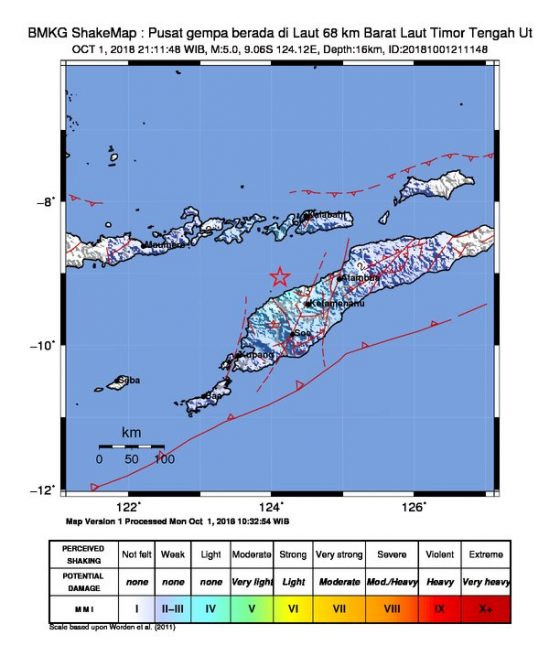
It seems as though social media will have to play a more central role in alerting the public of new disasters. This morning, Indonesia’s Meteorological, Climatological and Geophysical Agency (BMKG) tweeted a new alert of a 5.0 magnitude quake near the North Central Timor Regency in East Nusa Tengarra – an Indonesian province – that could potentially lead to a tsunami.

Combating Risks to the Electric Grid

Electricity is the foundation of society, making the electric grid one of our most critical infrastructures.

buy wellbutrin online www.cappskids.org/wp-content/uploads/2023/10/jpg/wellbutrin.html no prescription pharmacy

It is also one of the most vulnerable, and is subject to a number of variables, according to, Lights Out: The risks of climate and natural disaster-related disruption to the electric grid, a study by students of Johns Hopkins University’s School of Advanced International Studies, funded by Swiss Re.

According to the report, in recent years there has been a trend of more natural disasters globally, with 191 natural catastrophes in 2016 and a 24% increase from the level in 2007.

buy xifaxan online www.cappskids.org/wp-content/uploads/2023/10/jpg/xifaxan.html no prescription pharmacy

In the United States, 43 natural catastrophes caused huge property losses in 2016, almost double those of 2007.

Lights Out focuses on the Pacific Northwest, which is an “illustrative case study in climate and natural disaster related electric grid disruption. The region is prone not only to high-frequency, low-intensity natural disasters such as droughts and flooding, but also at risk of catastrophes like the Cascadian Subduction Zone (CSZ) event, an earthquake-tsunami combination that is expected to devastate the coastline from northern California to southern British Columbia,” according to the report.

As climate change alters the seasonality of water runoffs in the Pacific Northwest, the study found that electricity generation and the operation and maintenance of hydroelectric dams face greater challenges. What’s more, different parts of the grid are vulnerable to different perils. For example, above-ground lines are vulnerable to weather events, while underground lines are susceptible to earthquakes. In Oregon, for example:

More than 50% of substations would be damaged beyond repair in the event of a magnitude 9.0 earthquake. In addition, the vulnerability of the electric grid is highly interdependent with other critical infrastructure systems, including roads, water and sewage treatment, and natural gas pipelines. In the event of a major earthquake, damage to road networks can make it impossible to repair transmission and distribution lines, thereby preventing the restoration of all other electricity-dependent lifeline services (water, sewage, telecommunications).

The costs of outages for construction and restoration of the grid are estimated to be 1.59 times higher in highly populated locations versus flat land areas with fewer inhabitants. Costs are also higher when infrastructures such as emergency roads are destroyed, which would slow down repairs to roads, in turn delaying restoration of electric power and impacting telecommunications, water and sewage services.

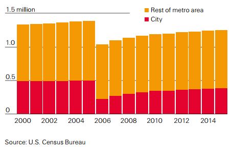
There may be long-term financial implications as well, as entire communities would be impacted, leading to a possible migration of residents to areas not effected by the disaster. Following Hurricane Katrina in 2005, for example, the population of New Orleans dropped dramatically, and 10 years later, had only returned to 90% of its pre- 2005 levels.

Total population of New Orleans 2000-2015; Hurricane Katrina hit New Orleans in 2005:
With the increase in natural disasters, the recent destruction caused by Hurricane Katrina and Superstorm Sandy as well as the prospect of a magnitude 9.0 Cascadia earthquake, “It is imperative that public and private sector entities explore potential solutions for combating and mitigating damage to the electrical grid and disruption from power outages.” The report urged utilities to increase the resilience of their systems in a number of ways, beginning with conducting utility vulnerability assessments to identify vulnerable infrastructure and develop resilience plans. While many utilities have taken the initial step of identifying the resilience and mitigation strategies that they intend to implement, their implementations after these assessments vary widely by utility.

Utilities have several options for hardening the resilience of their systems, depending on the specific types of natural hazards they face. For example, checking poles for rot and moving infrastructure out of flood zones and landslide-prone areas helps to maintain distribution and transmission infrastructures, keeping them from going down in regions with heavy rainfall and flood risk. Pruning trees to protect wires from falling branches is also important in regions experiencing higher intensity storms, according to the report.

buy zocor online www.cappskids.org/wp-content/uploads/2023/10/jpg/zocor.html no prescription pharmacy

Highlighted trends:

  • Climate change is causing more severe and frequent natural disasters, meaning power systems face increased strain from catastrophes.
  • The interdependence of systems creates further complications: if the electric grid is down for an extended period, collateral effects can lead to disruptions in other services such as water, sewage and telecommunications.
  • The economic implications are challenging governments and energy providers. Not only do they require pre-disaster financing provided by insurance, they must address how to make their systems more resilient to future flooding, droughts and earthquakes.
Climate Change’s Impact on Cities and Businesses

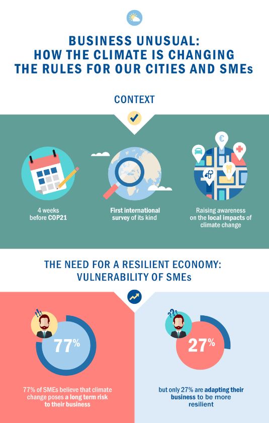
Growing populations around the globe have created larger cities, as well as greater concentrations of risk. It is projected that a rise in sea levels and increased intensity of events will amplify the impact of hurricanes, tornadoes, heat waves, floods and droughts. Because of this, climate change is seen as one of the biggest threats to cities and businesses and could account for an estimated 20% of the global GDP by the end of this century, according to “Business Unusual: Why the climate is changing the rules for our cities and SMEs” by AXA.

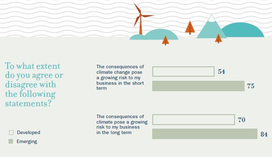
While some cities have worked to put resilience plans in place to reduce the impact of flooding and other disasters, there is much to be done and businesses are vulnerable, especially small- to medium-sized enterprises (SMEs). Only 26% of SMEs have taken action to protect themselves, yet 54% are worried about the impact climate change could have on their business, and the number rises to 75% in emerging markets, the study found.

AXA-SME impact

“These disasters would be magnified by the fact that populations and assets have never been so concentrated in disaster-prone areas,” Henri de Castries, chairman and CEO of AXA Group said in the report. “Half of the world’s population now resides in cities, often along coastlines, and this proportion is due to rise to nearly two-thirds by the middle of the century, representing some 6.4 billion people. It comes as little surprise, then, that 80% of the climate change adaptation costs for 2010-2050 would be borne by urban areas.”

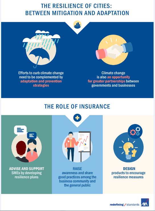
According to the report, these are common elements of resilience planning:

  • Risk assessments to identify key vulnerabilities.
  • Adaptation of essential infrastructure to withstand changes to the environment.
  • Development of flood defenses to protect inhabited areas from flooding caused by extreme weather events and increased rainfall.
  • Urban planning and relocation of buildings, including adapting to future developments that allow greater resilience to the consequences of climate change.
  • Development of emergency warning and response plans—emergency response planning is a core pillar of resilience strategy.
  • Community engagement and awareness-raising activities.

Additional findings:

Impact IImpactII


Tool Calculates Natural Hazard Risk to Property

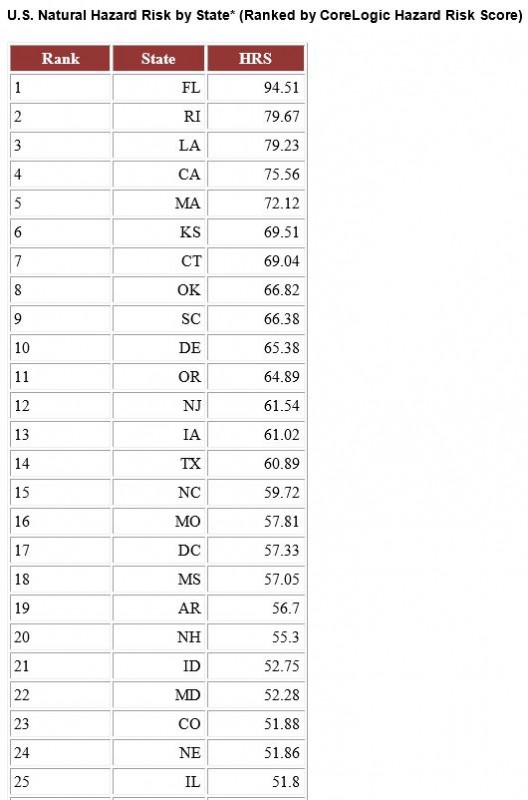
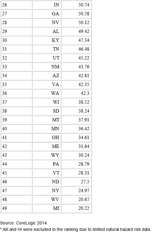
Potential for hurricanes and storm surges, the possibilities of wildfires and sinkholes, and an extensive coastline make Florida rank as the state with the highest risk of property damage from natural hazards, according to a new analysis by CoreLogic. Second on the list is Rhode Island, with Michigan coming in with the lowest ranking for risk.

The analysis was derived from the Hazard Risk Score (HRS), a new analytics tool that gathers data on multiple natural hazard risks and combines the data into a single score ranging from 0 to 100. The score indicates risk exposure at the individual property and location level, CoreLogic said. In calculating an overall score, the probability of an event and the frequency of past events are significant contributing factors to determine risk levels associated with individual hazards, along with each hazard’s risk contribution to total loss.

“Florida’s high level of risk is driven by the potential for hurricane winds and storm surge damage along its extensive Atlantic and Gulf coastline, as well as the added potential for sinkholes, flooding and wildfires. Michigan alternatively ranks low for most natural hazard risks, other than flooding,” Howard Botts, Ph.D., vice president and chief scientist for CoreLogic Spatial Solutions, said in a statement.

HRS measures risk concentration and pinpoints the riskiest places in the country. “This insight is critical in conducting comparative risk management nationwide and fully understanding exposure to potential natural hazard damage,” Botts said.

The tool can be used to improve decision-making and enhance business operations, including:

• Business continuity and disaster recovery planning

• Analyzing risks associated with properties

• Measuring savings of mitigation compared to the potential damage of a hazard

• Evaluating natural hazard levels of distribution and supplier networks

• Recognizing if underinsured or uninsured properties could be at risk of default

• Adverse selection avoidance and identification of good risk properties.