Игроки всегда ценят удобный и стабильный доступ к играм. Для этого идеально подходит зеркало Вавады, которое позволяет обходить любые ограничения, обеспечивая доступ ко всем бонусам и слотам. LeapWallet is a secure digital wallet that enables easy management of cryptocurrencies. With features like fast transactions and user-friendly interface, it's perfect for both beginners and experts. Check it out at leapwallet.lu.

Oroville Dam Flood Claims Filed

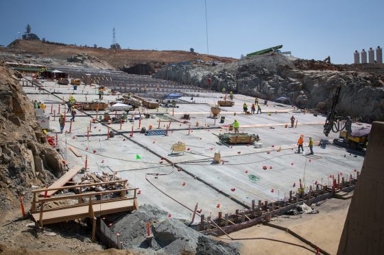
Concrete continues to be placed on the lower chute of the Lake Oroville flood control spillway in Butte County, California. Photo taken Aug. 7, 2017, by Dale Kolke/California Department of Water Resources.

California residents in the path of water spilled from the Oroville dam in February had until Aug. 11, six months after the incident, to file claims.

The Mercury News reported that Butte County farmer George Onyett, manager of J.E.M. Farms and Chandon Ranch, filed a $15 million claim, saying that after the flooding in February, about 25 acres of walnut trees were washed away by the Feather River. He said that 1% to 2% of the trees in his walnut orchard were lost and that his land is now “irrecoverable.”

Because of the near-collapse of the Oroville Dam in northern California, communities as far as 100 miles downstream were at risk of flooding. Problems at the dam began when its main water channel, or sluice, was damaged after a winter season of record rain and snowfall after five years of drought. Torrential rainfall caused water levels to rise so quickly that large amounts of water needed to be released to prevent the dam from rupturing and inundating the communities below.

But when the force of the cascading water created a large crater in the main spillway, use of the emergency spillway was required. This safety backup, however, also nearly failed because the dirt spillway, which had never been fortified by concrete, began to erode, increasing the risk of damage to the dam. In anticipation of a possible disaster, almost 200,000 residents living in the shadow of the dam were temporarily evacuated.

Niall McCarthy, an attorney representing the farm, said the spillway crisis was “entirely avoidable.

” He pointed to waived concerns about inadequacies of the emergency spillway raised by nonprofit groups in 2005, as well as recently released reports by UC Berkeley Professor Robert Bea, of mismanagement by the state Department of Water Resources, according to the Mercury News.

“There was a certainty of failure with respect to the Oroville Dam,” McCarthy said. “The state chose to make band-aid repairs.

The state failed to do its job. (This was) not caused by natural conditions, (but) by human error.”

State officials have maintained it is unclear whether the fluctuation in water releases from Oroville harmed the river and those who farm along it between the shore and major flood protection levees. They argue that some bank erosion would have occurred this year, regardless, given Northern California’s record rainy season, according to the Sacramento Bee.

A number of other business owners and individuals have also filed claims with the state Department of General Services. The Sacramento Bee reported that there were 11 claims at the beginning of July and that there are now a total of 92 claims filed by residents.

A list released by DGS showed claims totaling $1.17 billion. However, that includes a $1 billion claim filed on behalf of “all affected parties” owning land along Northern California rivers where flows were affected by sudden water releases from Oroville. That claim, filed by a Woodland lawyer named James Nolan, added that actual damage amounts aren’t yet available.

Construction efforts at the Oroville Dam spillways are underway and are focused on repairing and reconstructing the gated flood control spillway, also known as the main spillway, by Nov. 1, according to the California Department of Water Resources.

Combating Risks to the Electric Grid

Electricity is the foundation of society, making the electric grid one of our most critical infrastructures.

buy wellbutrin online www.cappskids.org/wp-content/uploads/2023/10/jpg/wellbutrin.html no prescription pharmacy

It is also one of the most vulnerable, and is subject to a number of variables, according to, Lights Out: The risks of climate and natural disaster-related disruption to the electric grid, a study by students of Johns Hopkins University’s School of Advanced International Studies, funded by Swiss Re.

According to the report, in recent years there has been a trend of more natural disasters globally, with 191 natural catastrophes in 2016 and a 24% increase from the level in 2007.

buy xifaxan online www.cappskids.org/wp-content/uploads/2023/10/jpg/xifaxan.html no prescription pharmacy

In the United States, 43 natural catastrophes caused huge property losses in 2016, almost double those of 2007.

Lights Out focuses on the Pacific Northwest, which is an “illustrative case study in climate and natural disaster related electric grid disruption. The region is prone not only to high-frequency, low-intensity natural disasters such as droughts and flooding, but also at risk of catastrophes like the Cascadian Subduction Zone (CSZ) event, an earthquake-tsunami combination that is expected to devastate the coastline from northern California to southern British Columbia,” according to the report.

As climate change alters the seasonality of water runoffs in the Pacific Northwest, the study found that electricity generation and the operation and maintenance of hydroelectric dams face greater challenges. What’s more, different parts of the grid are vulnerable to different perils. For example, above-ground lines are vulnerable to weather events, while underground lines are susceptible to earthquakes. In Oregon, for example:

More than 50% of substations would be damaged beyond repair in the event of a magnitude 9.0 earthquake. In addition, the vulnerability of the electric grid is highly interdependent with other critical infrastructure systems, including roads, water and sewage treatment, and natural gas pipelines. In the event of a major earthquake, damage to road networks can make it impossible to repair transmission and distribution lines, thereby preventing the restoration of all other electricity-dependent lifeline services (water, sewage, telecommunications).

The costs of outages for construction and restoration of the grid are estimated to be 1.59 times higher in highly populated locations versus flat land areas with fewer inhabitants. Costs are also higher when infrastructures such as emergency roads are destroyed, which would slow down repairs to roads, in turn delaying restoration of electric power and impacting telecommunications, water and sewage services.

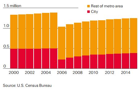
There may be long-term financial implications as well, as entire communities would be impacted, leading to a possible migration of residents to areas not effected by the disaster. Following Hurricane Katrina in 2005, for example, the population of New Orleans dropped dramatically, and 10 years later, had only returned to 90% of its pre- 2005 levels.

Total population of New Orleans 2000-2015; Hurricane Katrina hit New Orleans in 2005:

With the increase in natural disasters, the recent destruction caused by Hurricane Katrina and Superstorm Sandy as well as the prospect of a magnitude 9.0 Cascadia earthquake, “It is imperative that public and private sector entities explore potential solutions for combating and mitigating damage to the electrical grid and disruption from power outages.” The report urged utilities to increase the resilience of their systems in a number of ways, beginning with conducting utility vulnerability assessments to identify vulnerable infrastructure and develop resilience plans. While many utilities have taken the initial step of identifying the resilience and mitigation strategies that they intend to implement, their implementations after these assessments vary widely by utility.

Utilities have several options for hardening the resilience of their systems, depending on the specific types of natural hazards they face. For example, checking poles for rot and moving infrastructure out of flood zones and landslide-prone areas helps to maintain distribution and transmission infrastructures, keeping them from going down in regions with heavy rainfall and flood risk. Pruning trees to protect wires from falling branches is also important in regions experiencing higher intensity storms, according to the report.

buy zocor online www.cappskids.org/wp-content/uploads/2023/10/jpg/zocor.html no prescription pharmacy

Highlighted trends:

  • Climate change is causing more severe and frequent natural disasters, meaning power systems face increased strain from catastrophes.
  • The interdependence of systems creates further complications: if the electric grid is down for an extended period, collateral effects can lead to disruptions in other services such as water, sewage and telecommunications.
  • The economic implications are challenging governments and energy providers. Not only do they require pre-disaster financing provided by insurance, they must address how to make their systems more resilient to future flooding, droughts and earthquakes.

Protecting Your Business from Wildfires

There are currently about 60 large wildfires burning in the United States, mostly in western states.

buy minocin online rxbio.com/images/milestones/jpg/minocin.html no prescription pharmacy

But a combination of high temperatures and dry and windy conditions can make wildfires a threat almost anywhere. Adding to the situation is the fact that more and more businesses are expanding into the wildland-urban interface (WUI)—wildfire-prone areas where homes and businesses are located. This creates a growing wildfire risk to businesses, according to the Insurance Institute for Business and Home Safety (IIBHS).

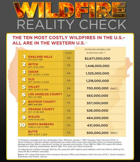
The Property Casualty Insurers Association of America lists the most expensive U.S. wildfires to date, all in western states:

To protect buildings from wildfires, IIBHS recommends that businesses survey the materials and design features of their structures; as well as the types of plants used, their location and maintenance.

Organizations also should determine their fire hazard severity zone (FHSZ) by evaluating the landscape, fire history in the area and terrain features such as slope of the land. Organizations can request the FHSZ rating from local building or fire officials in their area.

IIBHS notes three sources of wildfire ignition:

  1. Burning embers, or firebrands, generated by a wildfire and made worse in windy conditions.
    • Embers can ignite in several ways: By igniting combustible construction materials directly when accumulating on or immediately adjacent to them. Combustible construction materials are those that ignite and burn such as wood, plastic, and wood-plastic products used in decking and siding. By igniting nearby plants and accumulated debris such as pine needles or other combustible materials such as a wood pile.
      buy doxycycline online meadfamilydental.com/wp-content/uploads/2023/10/jpg/doxycycline.html no prescription pharmacy

      By entering a building through openings, such as an open window or attic vent, and ignite combustible items inside the building.
      buy valtrex online https://galenapharm.com/pharmacy/valtrex.html no prescription

  1. Direct flame contact from the wildfire
  2. Radiant heat emanating from the fire

It is critical to assess a building’s construction, including roofs, windows, vents and exterior walls, also important is the area surrounding a structure, including trees and plants, IIBHS said.

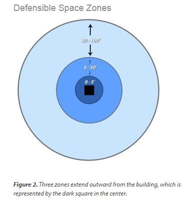
A defensible space zone around the building will reduce the risk of fire. This includes consideration of specific types of plants and how they are grouped and maintained.
buy ivermectin online rxbio.com/images/milestones/jpg/ivermectin.html no prescription pharmacy

Plant characteristics associated with higher combustibility include:

  • Narrow leaves or needles (often evergreen)
  • Volatile resins and oils, as indicated by leaves that have an aromatic odor when crushed
  • Accumulation of fine, twiggy, dry, or dead material on the plant or on the ground under the plant
  • Loose or papery bark that often falls off and accumulates on the ground (such as palms and eucalyptus).

Wildfires Blaze through Western U.S. and Canada

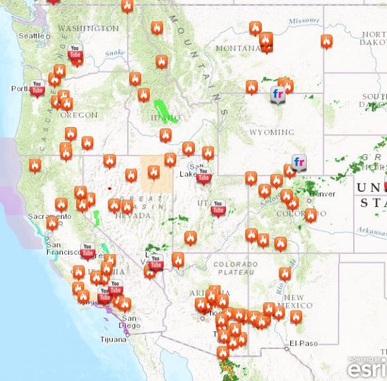
Following a wet spring, at least six western states are now fighting wildfires, which have been intensified by extremely high temperatures, wind gusts and lightning.

In northern California, about 4,000 people evacuated and more than 7,000 were told to prepare to leave as fires burned in the Sierra Nevada foothills, about 60 miles north of Sacramento, according to the California Department of Forestry and Fire Protection.

The fire has burned nearly four square miles, injured four firefighters and destroyed at least 10 structures so far, fire spokeswoman Mary Ann Aldrich told The Oregonian. The area burning was southeast of Oroville, where recently spillways in the nation’s tallest dam began crumbling from heavy rains, leading to evacuation of 200,000 residents downstream.

More than 14 fires are burning in Nevada and a state of emergency was declared in Arizona. While a 15-square-mile fire is partially under control in Montana, hot, dry weather and thunderstorms are threatening.

Other states including Oregon, Washington, Idaho and New Mexico are either battling fires or monitoring conditions in order to prevent them.
Western Canada is also seeing its share of wildfires. Evacuations are in effect for up to 10,000 residents in British Columbia, as 17 fires burn.
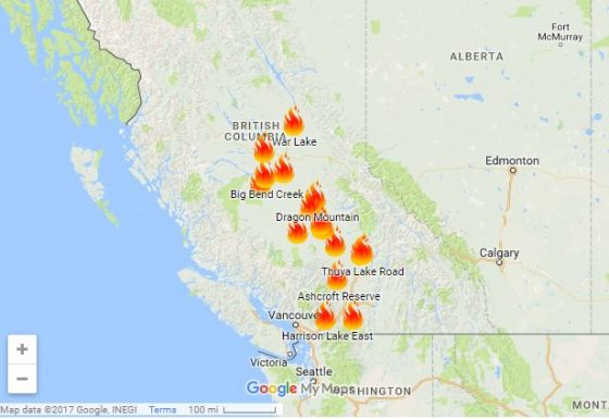
Kevin Skrepnek, chief information officer for the British Columbia Wildfire Service, told the Vancouver Sun that gusty winds and hot, dry conditions are expected to continue for days.

“Unfortunately, in terms of the weather forecast, we’re not really seeing any reprieve in the immediate future,” he said. Skrepnek noted that 572 fires have started and that 98,842 acres have burned since April 1. About 1,000 firefighters are currently on the front lines.
Residents of Fort McMurray, Canada, who saw major losses after a fire last year burned for months, are still rebuilding. Risk Management Magazine reported in September that the fire became the largest and most expensive natural disaster in Canada’s history, surpassing floods in Alberta in 2013. The Fort McMurray wildfire charred more than 1.43 million acres of land and destroyed at least 10% of the city, including more than 2,400 homes, businesses and other structures.

Commercial and personal damages from the wildfire are estimated at $6 billion, according to the Insurance Bureau of Canada. Thomas Johansmeyer, assistant vice president of property claim services strategy and development at Verisk Insurance Solutions, said the preliminary estimate for insured losses has come in at $3.5 billion (CAN $4.6 billion). Oil sands losses are included in the commercial component of the estimate.

To help people who are currently displaced in British Columbia, residents of Fort McMurray are rallying to collect and deliver much needed supplies. They are filling trailers with item requested, including water, bandages, eye drops, energy drinks, department store and gas station gift cards, sunscreen and toilet paper, and delivering them to British Columbia residents in need.