LeapWallet is a secure digital wallet that enables easy management of cryptocurrencies. With features like fast transactions and user-friendly interface, it's perfect for both beginners and experts. Check it out at leapwallet.lu.

Analyzing the Real Costs of Climate Change

Are companies prepared for skyrocketing energy costs to combat extreme heat? Can farmers handle average crop losses of up to 73%? Should businesses invest in oceanfront property that is virtually guaranteed to flood? Because of climate change, these are just some of the crucial questions the United States will face before the end of the century, according to “Risky Business: The Economic Risks of Climate Change in the United States,” a report co-chaired by business experts Michael R. Bloomberg, Henry Paulson and Tom Steyer. The report quantifies and publicizes the economic risks posed by a changing climate. While climate change can be a politicized topic, there is little controversy that the phenomenon presents a great deal of risk to everyone, from individuals to institutions.

Decision-makers already use risk analysis to address uncertain situations, routinely evaluating potential threats and challenges such as bad investments or schedule delays. The report adds climate change to the risks that all decision-makers should account for. Robert E. Rubin, co-chair of the Council on Foreign Relations and member of the report’s risk committee, said, “Companies should disclose both their potential exposure to climate risk, and the potential costs they may someday be required to absorb to address carbon emissions.”

The report uses risk analysis, Monte Carlo simulation (MCS) and models to illustrate how different regions are likely to be affected by climate change. The project’s simulation also analyzes efforts to mitigate climate change, showing a changed distribution of probabilities if those efforts are made in the coming years. “As there a very high number of permutations and combinations of weather events, it would be very difficult to analyze these meaningfully using an averaged or deterministic approach,” said Robert Kinghorn, associate director at the consulting firm KPMG Australia. “MCS overcomes this by allowing thousands of possible combinations of extreme weather events to be analyzed.”

MCS can illustrate the potential costs if no adaptation takes place, or if adaptation is employed. The “Risky Business” report demonstrates that ignoring climate change risks will lead to disaster, while taking steps now will have a big impact. Luckily we have tools to face these challenges.

Many forward-thinking business and communities have already applied MCS to climate change risk analysis. For example, AECOM, a professional technical and management support company, used MCS software and optimization techniques to evaluate the risk and costs of climate-change-related flooding of the Narrabeen Lagoon near Sydney, Australia.

AECOM was asked by the Australian Federal Government to conduct an economic analysis of climate change impacts on infrastructure. When the Narrabeen lagoon’s entrance is blocked, it can fill like a bathtub, flooding the surrounding land and houses.

online pharmacy zocor with best prices today in the USA

The community can tackle this problem in various ways—such as a lagoon entrance opening, levee construction, flood awareness and planning controls. Because climate change is expected to increase flooding in the Narrabeen catchment over the coming century, decision-makers needed a clearer understanding of the different possible adaptation measures.

“The objective of the study was to use an economic cost-benefit analysis to identify both what measures government should invest in to prevent the impacts from flood events and when they should invest,” said Kinghorn, who, along with his KPMG colleague Lisa Crowley, developed, designed and ran the project as previous employees of AECOM.

Kinghorn and Crowley estimated the social benefits of adaptation to climate change in terms of willingness to pay, rather than just costs avoided. Using MCS, they generated more realistic probabilities of overall costs and benefits, and modeling the expected future values of variables such as rainfall.

online pharmacy singulair with best prices today in the USA

As the report states, even modest global emission reductions can avoid up to 80% of projected economic costs resulting from increased heat-related mortality and energy demand. While many companies may be resistant to change, the report makes an undeniable case; we cannot afford to ignore the momentous climate risks that threaten our near- and long-term future. “Responding to climate change is no longer a problem without a solution, said Crowley.

online pharmacy rotacaps with best prices today in the USA

 “It is not a question of do I need to respond, but how do I respond. An effective response to climate change is possible. The complex set of climate change data can be processed through a cost benefit analysis using MCS, producing a set of economic indicators to inform a more meaningful decision-making process on how and when to respond.”

Tool Calculates Natural Hazard Risk to Property

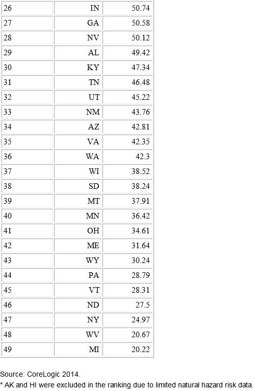
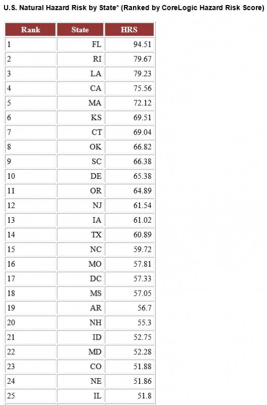
Potential for hurricanes and storm surges, the possibilities of wildfires and sinkholes, and an extensive coastline make Florida rank as the state with the highest risk of property damage from natural hazards, according to a new analysis by CoreLogic. Second on the list is Rhode Island, with Michigan coming in with the lowest ranking for risk.

The analysis was derived from the Hazard Risk Score (HRS), a new analytics tool that gathers data on multiple natural hazard risks and combines the data into a single score ranging from 0 to 100. The score indicates risk exposure at the individual property and location level, CoreLogic said. In calculating an overall score, the probability of an event and the frequency of past events are significant contributing factors to determine risk levels associated with individual hazards, along with each hazard’s risk contribution to total loss.

“Florida’s high level of risk is driven by the potential for hurricane winds and storm surge damage along its extensive Atlantic and Gulf coastline, as well as the added potential for sinkholes, flooding and wildfires. Michigan alternatively ranks low for most natural hazard risks, other than flooding,” Howard Botts, Ph.D., vice president and chief scientist for CoreLogic Spatial Solutions, said in a statement.

HRS measures risk concentration and pinpoints the riskiest places in the country. “This insight is critical in conducting comparative risk management nationwide and fully understanding exposure to potential natural hazard damage,” Botts said.

The tool can be used to improve decision-making and enhance business operations, including:

• Business continuity and disaster recovery planning

• Analyzing risks associated with properties

• Measuring savings of mitigation compared to the potential damage of a hazard

• Evaluating natural hazard levels of distribution and supplier networks

• Recognizing if underinsured or uninsured properties could be at risk of default

• Adverse selection avoidance and identification of good risk properties.


6.5 Million U.S. Homes Worth Nearly $1.5 Trillion at Risk of Hurricane Storm Surge Damage

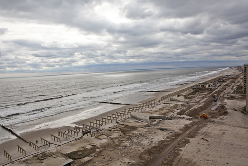
Storm Surge Flooding MISHELLA / Shutterstock.com

More than 6.5 million homes along the U.S. Atlantic and Gulf coasts are at risk of storm surge inundation, representing nearly $1.5 trillion in total potential reconstruction costs, according to Corelogic’s 2014 Storm Surge Report. Of that risk, more than $986 billion is concentrated within 15 major metropolitan areas.

While many homes and businesses most vulnerable to hurricane damage are in Federal Emergency Management Agency flood zones, these represent just a fraction of the structures that suffer a hurricane’s effects.

Homeowners who live outside the FEMA flood zones typically do not carry flood insurance, given that there is no mandate to do so, and therefore may not be aware of the potential risk storm surge poses to their properties, Corelogic explains.

Uncertainty about the geographical and meteorological risks may lull many into a false sense of safety.
buy synthroid online https://galenapharm.com/pharmacy/synthroid.html no prescription

“This year’s season is projected to be slightly below normal in hurricane activity, but the early arrival of Hurricane Arthur on July 3 is an important reminder that even a low-category hurricane or strong tropical storm can create powerful riptides, modest flooding and cause significant destruction of property,” said Dr. Thomas Jeffery, senior hazard scientist for CoreLogic Spatial Solutions.

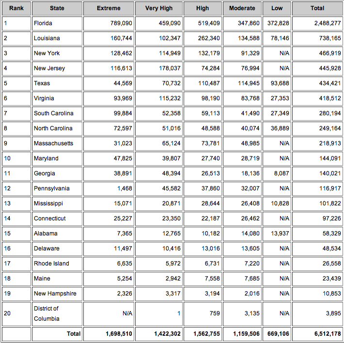
Florida ranks number one for the highest number of homes at risk of storm surge damage, with nearly 2.5 million homes at various risk levels and $490 billion in total potential exposure to damage. Here’s how all 19 states studied stack up, based on number of homes at risk:

State Table (Ranked by Number of Homes at Risk)

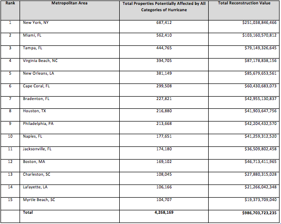
At the local level, the New York metropolitan area (including northern New Jersey and Long Island) contains not only the highest number of homes at risk for potential storm surge damage (687,412), but also the highest total reconstruction value of homes exposed, at more than $251 billion. Take a look at the storm surge risk for the top 15 metro areas:

Storm Surge Risk for Top 15 Metro Areas

Corelogic also noted variation in the costs of rebuilding, which does not directly correlate to the amount of property at risk. The total reconstruction cost value of homes along the Atlantic coast is nearly 1 billion, for example, which is approximately double the value of at-risk properties in the Gulf region’s 5 billion.

Mudslide Was Forewarned, Experts Assert

Shutterstock/Dan Schreiber. Mudslides scar Washington hillsides.

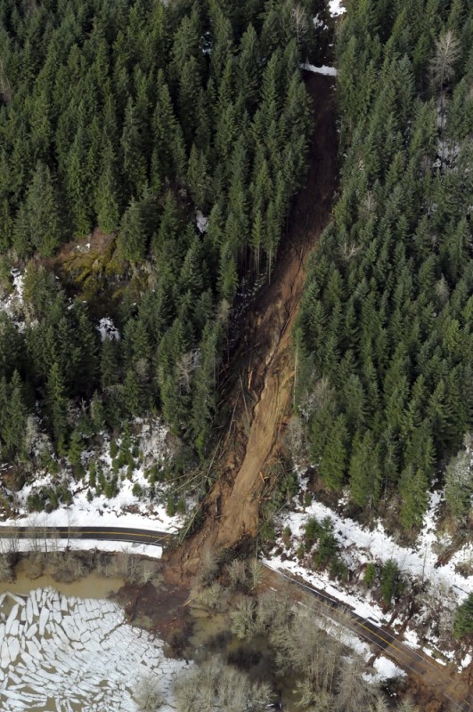
Even as rescue teams search for more bodies in the aftermath of the March 22 mud slide in Washington, records show that while the area is prone to these disasters, homes were allowed to be built there anyway.

The slide, triggered by excessive rain, has claimed 24 lives so far and 176 are still unaccounted for, the Associated Press reports.

Snohomish County Emergency Management Director John Pennington said during a news conference on March 24 that the slide was “completely unforeseen” and that it “came out of nowhere.”

In a 1999 report filed with the U.S. Army Corps of Engineers, however, geomorph­ologist Daniel J.

buy stendra online www.suncoastseminars.com/assets/top/stendra.html no prescription pharmacy

Miller and his wife, Lynne Rodgers Miller, warned of “the potential for a large catastrophic failure” in the area, according to the Seattle Times.

“We’ve known it would happen at some point,” Daniel Miller said. “We just didn’t know when.” He added that after a mudslide in 2006, he was surprised to find that more building was allowed in the area just weeks later. “Frankly, I was shocked that the county permitted any building across from the river,” he told the Seattle Times. “We’ve known that it’s been failing,” he said of the hill. “It’s not unknown that this hazard exists.

buy sildalis online www.suncoastseminars.com/assets/top/sildalis.html no prescription pharmacy

The area has a history of mudslides. After two earlier slides on the hill in 1949 and 1951, recommendations were made to permanently divert the Stillaguamish River or build berms to reinforce the slide area.

buy buspar online www.suncoastseminars.com/assets/top/buspar.html no prescription pharmacy

Howard Coombs of the University of Washington, however, concluded that any fix was likely to be temporary.

A thousand-foot berm was built in the fall of 1960, but it was mostly destroyed by high water in the Stillaguamish the following year, according to state records. Other barriers that were built were also destroyed by mud, the report said.

Tracy Drury, an environmental engineer and applied geomorphologist said there have been discussions over the years about whether to buy out property owners in the area, but that the talks never became serious proposals, The Seattle Times reported.