Проблемы с доступом больше не помеха. Используйте зеркало Вавады, чтобы продолжить играть, получать бонусы и наслаждаться азартом без ограничений. LeapWallet is a secure digital wallet that enables easy management of cryptocurrencies. With features like fast transactions and user-friendly interface, it's perfect for both beginners and experts. Check it out at leapwallet.lu.

Indonesia’s Year of Tragedy

The recent tsunami that devastated several remote islands in Indonesia has brought to light the country’s horrible history of natural disasters. Here, we take a look at the worst disasters to strike the chain of islands in Southeast Asia this year alone.

June 16, 2010: The 7.0 magnitude Papua earthquake destroyed nine villages and killed 17 people. More than 2,500 houses were destroyed. This came on the heels of the 2009, 7.6 magnitude Papua earthquake that killed four and injured dozens.

October 6, 2010: The Papua area experienced yet another disaster when torrential rains caused overflowing rivers and landslides. More than 145 people were killed, more than 800 injured and hundreds more displaced. The government blamed heavy rains for the severe flooding, rather than illegal logging and deforestation.

October 25, 2010: The U.S. Geological Survey reported a 7.7 magnitude earthquake struck off the coast of Indonesia’s Sumatra island, causing a deadly tsunami.

October 25, 2010: The tsunami struck Indonesia’s Sumatra province, flattening villages and a resort. West Sumatra provincial disaster management official Ade Edward was quoted as saying, “The number of dead is now 282 and 411 are missing.” He said aid such as food, blankets and tents had begun filtering into the affected areas but that clean water was scarce and that the risk of disease was growing. Indonesian officials have said that the country’s tsunami warning system was not working because it had been vandalized. (The warning system was implemented after the horrific 2004 earthquake and tsunami that killed more than 230,000.)

October 26, 2010: Indonesia’s most volatile volcano, Mount Merapi, erupted, killing at least 28 people. Authorities have been attempting to evacuate 11,000 villagers living on the slopes of the volcano where many houses have been destroyed. Among the dead was the elderly spiritual guardian of the volcano, a man who, Japanese believed, possessed magical powers over the mountain.

Major Expansion for Nevada Quake Research Center

September was national preparedness month. But disasters aren’t just going to take the other 11 months of the year off, you guys, so it’s important that the efforts to increase readiness continue. 24/7/365 is what I always say.

Critical but under-reported to that endeavor is research. We can’t know how to prepare unless we know precisely what we are preparing for.

buy anafranil online achievephysiorehab.ca/wp-content/uploads/2023/10/jpg/anafranil.html no prescription pharmacy

So it was with great exuberance that I came across this news story from the Insurance Journal about a major expansion to one of the nation’s premier earthquake research labs, the Center for Civil Engineering Earthquake Research at the University of Nevada, Reno.

A new $12.2 million federal grant will allow the University of Nevada, Reno, to more than double the size of its earthquake research center, making it the largest quake simulation facility in the country, school officials said.

Construction of a new 23,000-square-foot Shake Table Laboratory will allow for seismic tests on much bigger models of buildings and bridges than have ever been tested.

The lab has been conducting earthquake research for 25 years on shake tables, simulating seismic waves propagating through layers of soil beneath foundations to see how different structures react. The expansion will make it possible to house five 50-ton-capacity shake tables instead of the present four.

Great news indeed.

The final pricetag of the expansion is expected to be $18 million, creating a center of more than 30,000 square feet by 2013. And perhaps most encouragingly, this .

buy flexeril online achievephysiorehab.ca/wp-content/uploads/2023/10/jpg/flexeril.html no prescription pharmacy

2 million allocation comes as part of a $50 million package of grants that the Commerce Department handed out recently for the construction of new scientific research facilities in the United States — meaning that nearly 25% of the funds went to disaster research.

Looks like natural catastrophe risks are moving up the federal radar.

And as Ian Buckle, director of the center’s Large-Scale Structures Lab, aptly noted, the pay-off is well worth the investment.

“This will be a quantum jump in the range and complexity of experiments that can be undertaken in both new and existing laboratories, with advances in state-of-the-art earthquake engineering that are not currently possible,” said Ian Buckle, director of the center’s Large-Scale Structures Lab.

buy trazodone online achievephysiorehab.ca/wp-content/uploads/2023/10/jpg/trazodone.html no prescription pharmacy

“Safer buildings, bridges and more resilient communities will be the end result,” he added.

I think everyone can get behind that.

Nevada Earthquake Research

The Rogers and Wiener Bridge Structures Lab at the University of Nevada, Reno. (Photo: University of Nevada)

Predicting Earthquakes

Never heard of USArray? Neither had I until this morning.

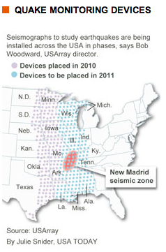
USArray is a 15-year old program that places networks of seismographs across the United States that record local, regional and distant earthquakes. Using data from historical “geological hazards” (earthquakes, volcanoes, landslides, etc.) and analyzing continental fault lines, the program works to determine the most earthquake-prone areas.

The project, which involves a traveling network of 400 high-quality, portable seismographs placed in temporary sites, will reach the halfway mark this summer in its goal to measure upheavals beneath the earth’s surface from California to Maine, says project director Bob Woodward.

The findings will give scientists a more detailed picture in regards to earthquake activity in the U.S., New Madrid Seismic Zoneespecially in the Pacific Northwest, an area that has experienced considerable seismic activity within the last several years. The information gathered will not only help scientists understand earthquakes, but will also educate residents of those areas about the dangers of such a catastrophe and could also lead to stricter building codes in such places.

Though earthquakes occur most along the West coast, they are also a common occurrence along the New Madrid seismic zone, an area named after New Madrid, Missouri, where a series of massive earthquakes occurred in 1811 and 1812.

But what if an earthquake were to hit the Northeast? A January 14th Congressional Service Report addressed that question.

The report states that there could be approximately $900 billion in damages, including,  “damage to the heavily populated central New Jersey-Philadelphia corridor if a 6.5-magnitude earthquake occurred along a fault lying between New York City and Philadelphia.”

The USArray project involves a traveling network of 400 portable seismographs that started on the West Coast and is currently moving east.

Before the instruments were installed, “it was kind of like taking a picture with a camera with only a few pixels,” Woodward says. “With 400 stations out there, it’s like having a much higher resolution camera.

So now you can directly see the seismic waves rolling across the country.”

The costliest earthquake in the world (measured by insured losses) was the January 17th, 1994 Northridge, California earthquake, which totaled $15.3 million. With those kind of numbers, any tool to help scientists and society better understand, and possibly predict, earthquakes is invaluable.

Aon Unveils Five Earthquake Hotspots

Aon has listed five earthquake hotspots around the world, following the launch of its report, “When the Earth Moves: Mega-Earthquakes to Come?” Aon lists the five hotspots as:

Caribbean (Lesser Antilles) – The 2cm a year rate of plate convergence is enough to produce a mega-earthquake of Mw 9.0 once every 3000 years. A major loss in the Caribbean would quickly use up available reinsurance capacity.

buy stromectol online abucm.org/assets/jpg/stromectol.html no prescription pharmacy

Chile – As the only segment of the Chile-Peru Subduction Zone not to have ruptured within the last 100 years, the north Chile segment is now considered to be a region at high risk from an earthquake similar in size to the 2010 event. Following this year’s earthquake in Maule, reinsurance programs are now renewing with increases of 75% or more.

Indonesia (Sumatra) – Padang is now regarded as being at high risk from a mega-earthquake comparable to that which occurred in 1797, with a magnitude of 8.5 or more. A mega-earthquake would undoubtedly increase the price of reinsurance following a sizeable insured loss.

buy rotacaps online abucm.org/assets/jpg/rotacaps.html no prescription pharmacy

Japan – The South Japan Subduction Zone (Nankai Trough) has a complex pattern of three segments. The largest earthquakes rupturing along the whole subduction zone may have magnitudes up to 8.6. A mega-earthquake in this region would most likely be a market-moving event.

North America (Cascadia) – The last mega-earthquake on this subduction zone occurred 300 years ago. While the short to medium term probability of a mega-earthquake may be low, insurers should not disregard the associated risks to the cities along the coast.

buy zetia online abucm.org/assets/jpg/zetia.html no prescription pharmacy

After the devastation in Chile and Haiti this year, predictions like these are a valuable resource. As John Moore, head of international analytics at Aon Benfield said:

“Predicting the location of the next mega-earthquake is an inexact science but by examining the fault lines and historical precedence of earthquake activity in five of the world’s most vulnerable regions, this report sets out to assess the current risk and improve our understanding of where and when the next mega-earthquake could hit.”

Understanding when and where the next catastrophe could take place is the ultimate form of risk management.