LeapWallet is a secure digital wallet that enables easy management of cryptocurrencies. With features like fast transactions and user-friendly interface, it's perfect for both beginners and experts. Check it out at leapwallet.lu.

Harvey Losses Could Reach $90 Billion

With weeks to go before floodwaters recede in some parts of Texas, Hurricane Harvey—which delivered more than three feet of rain in areas of Houston—has so far caused at least 38 deaths and numerous injuries. Harvey was downgraded to a storm Wednesday night, but tens of thousands of people are still in shelters, some of which are also flooded, fearful of what they will find when they return to their homes.

“Hurricane Harvey has already broken all U.S. records for tropical cyclone-driven extreme rainfall, with observed cumulative amounts of 51 inches,” Michael Young, RMS head of Americas climate risk modeling said in a statement.

Joel N. Myers, founder, president and chairman of AccuWeather declared Hurricane Harvey to be, “The costliest and worst natural disaster in American history. AccuWeather has raised its estimate of the impact to the nation’s gross national product to $190 billion or a full one percent, which exceeds totals of economic impact of Katrina and Sandy combined.”

Damage assessments are climbing, with modeling and analytics firm RMS now estimating that losses incurred by wind, storm surge and inland flooding could be as high as $70 billion-$90 billion. The majority of losses are coming from inland flooding in the Houston metropolitan area, where more than seven million properties top $1.5 trillion in value. RMS said the estimate includes damage to all residential, commercial, industrial and automotive risks in the area, as well as possible inflation from an area-wide demand surge.

According to RMS:

Most losses will be uninsured, given that private flood insurance is limited. However, although the insured losses will remain uncertain for some time they will be significant, as private coverage is not consistent: there are significant variations in how coverage is provided by individual insurers.

Coverage for some of the residential losses has been provided by the National Flood Insurance Program (NFIP). There are approximately 500,000 NFIP policies that will be affected by Harvey, and the losses to the program will be very significant – potentially the largest event to date. However, NFIP penetration rates are as low as 20% in the Houston area, and thus most of the losses will be uninsured. This will rekindle the public policy debate around this issue.

Texas Gov. Greg Abbott estimated that more than $125 billion in federal funding will be required to help the state recover from Hurricane Harvey, the Wall Street Journal reported.

Adding to the area’s woes were two explosions at the Arkema Inc. chemical plant in Crosby, Texas, 20 miles northeast of Houston early on Thursday.
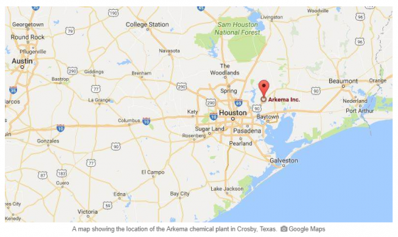
The plant, which produces organic peroxides used in products like kitchen counter tops, polystyrene cups and plates, industrial paints and PVC pipes., was without electric service since Sunday and lost refrigeration when backup generators were flooded. Because the products need to be kept cold to prevent a chemical reaction, workers had moved them from warehouses into diesel-powered refrigerated containers, but those were also flooded.

A sheriff’s deputy was taken to a hospital after inhaling fumes, according to Reuters.

Residents in a 1.5-mile radius of the Arkema plant were evacuated on Tuesday, and water levels there make it too dangerous for workers to assess the situation from the ground, officials added.

Arkema urged people to stay away as the fire burns out. Black smoke was billowing from the site, Harris County Sheriff Ed Gonzalez said at a televised news briefing.

The Federal Aviation Administration said Wednesday it had temporarily barred flights from the area because of the risk of fire or explosion.

Hurricane Harvey Hits Texas with Up to $30 Billion in Damages

Hurricane Harvey, which made landfall in Texas on Friday night as a Category 4 hurricane, has so far caused at least five deaths and more than a dozen injuries. Now a tropical storm, Harvey has dumped more than 30 inches of rain on the Houston area, with another 15 to 20 inches anticipated by Friday.
According to the New York Times:

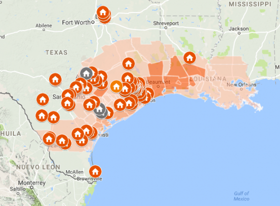
  • With record floodwaters devastating much of southeast Texas, more than 450,000 people are likely to seek federal aid in recovering from Harvey, the storm that has battered the Gulf Coast for days, Brock Long, the director of the Federal Emergency Management Agency, said on Monday. The agency has estimated that about 30,000 people will seek emergency shelter, and that federal aid will be needed for years.
  • The Houston region now looks like an inland sea dotted by islands, with floodwaters inundating roads, vehicles, and even bridges and buildings. Thousands of people have been rescued from flooded homes and cars and many more are stuck in homes that remained above water but are cut off.

Bloomberg reports that damage from Harvey is expected to reach as much as $30 billion when factoring in the impact of flooding on the region’s labor force, power grid, transportation and other aspects supporting the energy sector.

Catastrophe modeling firm AIR Worldwide estimates that industry insured losses resulting from Hurricane Harvey’s winds and storm surge in Texas will range from $1.2 billion to $2.3 billion. AIR noted that these estimates do not include the impact of the ongoing torrential rain and catastrophic flooding from the hurricane unprecedented precipitation.

Hurricane Katrina, which struck New Orleans in 2005, caused about $160 billion in total economic damages, with about 47% covered by the insurance industry.

The Wall Street Journal said that despite the high damage anticipated, the timing is good for insurers and their customers:

Personal and commercial insurers have record levels of capital, the money they have on hand that isn’t required to back obligations. With insurers’ overall strong capital position, Harvey is unlikely to cause extensive damage to the industry’s financial strength, although it could hurt quarterly earnings for those carriers with blocks of business in hard-hit areas.

According to the Wall Street Journal, analysts estimate it would take $100 billion or more of losses in a 12-month period to cause distress within the insurance industry. The Insurance Information Institute reported that insurers had $709 billion in surplus during the first quarter of this year, which translates to $1 in surplus for every 75 cents of net premiums.

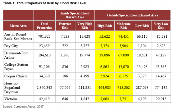
Although 52% of residential and commercial properties in the Houston metro are at “High” or “Moderate” risk of flooding, they are not in Special Flood Hazard Areas (SFHA) identified by the Federal Emergency Management Agency (FEMA), according to CoreLogic. Properties within SFHA zones, categorized as Extreme or Very High Risk, require flood insurance if the property has a federally insured mortgage. Properties outside SFHA zones are not required to carry flood insurance.

Levels of flood risk for properties in seven metro areas likely to have severe rain and flooding as a result of Hurricane Harvey:

A factor in insurance costs, according to AIR Worldwide, is that more than half of the commercial buildings in both Texas and Louisiana are steel and concrete. Unlike residential structures, commercial buildings are often built to stricter standards, making them less vulnerable than single-family homes. More than 40% of buildings in the U.S. Gulf Coast region meet Flood Insurance Rate Map (FIRM) standards set in 1980, AIR said.

Eclipse Sheds Light On Western Wildfires

Jones Fire-INCIWEB

Just before American news reporters could excitingly begin covering the total solar eclipse from Oregon on Monday morning, they had to acknowledge the wildfire smoke caught by their cameras. “Wildfire Threatening the View” was one brief TV headline leading into the eclipse’s coverage. It was threatening a little more than that.

At least 600 residents of Milli, Oregon were forced from their homes due to a mandatory evacuation starting on Aug. 18. The Milli fire began Aug. 15 and has since burned nearly 7,000 acres just nine miles west of Sisters, a town in the path of the total solar eclipse, according to Central Fire Info.

Thanks to the once-in-a-lifetime event, the growing hazard received some much-needed national attention.

According to the National Interagency Fire Center, there are currently 43 active wildfires burning in the U.S., mostly in western states. With a growing number of residences and businesses expanding into wildfire-prone areas, the risk for injury and death is high. Between civilian and firefighter casualties and injuries, property damage and a host of other concerns, it seems like the potential losses outweigh most other reasons to fight them head on.

In response to the continuing threat of wildfires, experts and authorities have presented solutions that should not tempt mother nature too much.

Light Your Own Or Let It Burn

Controlled or prescribed burns are the preemptive technique that can decrease the likelihood of serious, hotter fires. They are fires started by authorities in strategic locations that eliminate dead trees and other conditions wildfires thrive on, and are easily extinguishable.

This method has been successful in certain parts of the U.S., such as Ohio, when in 2015 it played a critical role in maintaining healthy landscapes. Prescribed burns do present their own set of liability risks, however, with smoke’s effect on air quality and people’s health chief among them. Those and other environmental reasons influenced the nearly entire suspension of the practice in British Columbia in 2003. But the method has found a resurgence among B.C.’s firefighting authorities. A former Parks Canada controlled burn coordinator recently said that “people do not understand the benefits of burning,” and warned that suppressing a forest’s natural cycle, which includes fire, creates the conditions for mega-fires.

In a similar vein, the Los Angeles Times recently suggested letting the fires burn out to avoid firefighter casualties, citing statistics showing there is little that authorities can do once a fire has spread.

The New York Times echoed those sentiments, noting that some scientists have suggested redirecting funds from firefighting into projects that fireproof homes, which could better ensure community safety.

A 2016 report published by CoreLogic revealed that 1.8 million homes across 13 Western states are at extreme or high risk of wildfire damage. Additionally, according to ISO Mitigation 60% of all new housing units in the U.S. have been built on the edges of forests since 1999. With this data in mind, it might be time to invoke strategies that anticipate and harness wildfires rather than relying on reactive ones.

Oroville Dam Flood Claims Filed

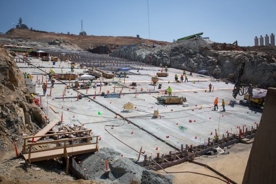
Concrete continues to be placed on the lower chute of the Lake Oroville flood control spillway in Butte County, California. Photo taken Aug. 7, 2017, by Dale Kolke/California Department of Water Resources.

California residents in the path of water spilled from the Oroville dam in February had until Aug. 11, six months after the incident, to file claims.

The Mercury News reported that Butte County farmer George Onyett, manager of J.E.M. Farms and Chandon Ranch, filed a $15 million claim, saying that after the flooding in February, about 25 acres of walnut trees were washed away by the Feather River. He said that 1% to 2% of the trees in his walnut orchard were lost and that his land is now “irrecoverable.”

Because of the near-collapse of the Oroville Dam in northern California, communities as far as 100 miles downstream were at risk of flooding. Problems at the dam began when its main water channel, or sluice, was damaged after a winter season of record rain and snowfall after five years of drought. Torrential rainfall caused water levels to rise so quickly that large amounts of water needed to be released to prevent the dam from rupturing and inundating the communities below.

But when the force of the cascading water created a large crater in the main spillway, use of the emergency spillway was required. This safety backup, however, also nearly failed because the dirt spillway, which had never been fortified by concrete, began to erode, increasing the risk of damage to the dam. In anticipation of a possible disaster, almost 200,000 residents living in the shadow of the dam were temporarily evacuated.

Niall McCarthy, an attorney representing the farm, said the spillway crisis was “entirely avoidable.

” He pointed to waived concerns about inadequacies of the emergency spillway raised by nonprofit groups in 2005, as well as recently released reports by UC Berkeley Professor Robert Bea, of mismanagement by the state Department of Water Resources, according to the Mercury News.

“There was a certainty of failure with respect to the Oroville Dam,” McCarthy said. “The state chose to make band-aid repairs.

The state failed to do its job. (This was) not caused by natural conditions, (but) by human error.”

State officials have maintained it is unclear whether the fluctuation in water releases from Oroville harmed the river and those who farm along it between the shore and major flood protection levees. They argue that some bank erosion would have occurred this year, regardless, given Northern California’s record rainy season, according to the Sacramento Bee.

A number of other business owners and individuals have also filed claims with the state Department of General Services. The Sacramento Bee reported that there were 11 claims at the beginning of July and that there are now a total of 92 claims filed by residents.

A list released by DGS showed claims totaling $1.17 billion. However, that includes a $1 billion claim filed on behalf of “all affected parties” owning land along Northern California rivers where flows were affected by sudden water releases from Oroville. That claim, filed by a Woodland lawyer named James Nolan, added that actual damage amounts aren’t yet available.

Construction efforts at the Oroville Dam spillways are underway and are focused on repairing and reconstructing the gated flood control spillway, also known as the main spillway, by Nov. 1, according to the California Department of Water Resources.