Игроки всегда ценят удобный и стабильный доступ к играм. Для этого идеально подходит зеркало Вавады, которое позволяет обходить любые ограничения, обеспечивая доступ ко всем бонусам и слотам.

Fort McMurray Wildfire Insured Losses Up to $6.9 Billion

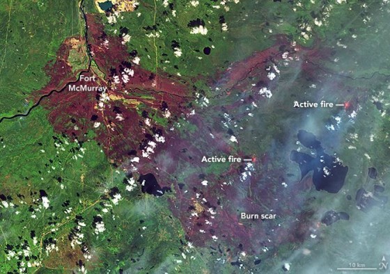
Ft-McMurray map

NASA Fort McMurray wildfire map

Insured loss estimates from the wildfire in Fort McMurray, Alberta, Canada, are projected between $3.4 billion and $6.9 billion, catastrophe modeling firm AIR Worldwide reported. Officials are still in the early stages of assessing damage caused by the wildfire that began on May 1 and quickly spread from forests to neighborhoods, outpacing local firefighters’ capacity to contain it. According to AIR, the Fort McMurray wildfire is the costliest natural disaster in Canada’s history.

The fire had initially moved away from Fort McMurray, but shifted back toward the city this week, causing evacuations for the second time. About 500 to 600 people were evacuated from four small work camps, Alberta Premier Rachel Notley said in a news conference on Monday.

The fire is still uncontained and, as of May 14, had covered nearly 600,000 acres, mainly in wildlands and away from population centers. Winds are now calmer and temperatures have lowered, with considerable cloud cover and a possible shower expected—all of which are expected to help firefighting efforts.

The fire’s new threat reversed earlier efforts to return local oil sands projects to full operation, the New York Times reported. The highway through Fort McMurray was reopened several days ago to allow workers to return to the work sites, but was closed again on Monday.

Premier Notley said that five things need to be in place before residents may reenter Fort McMurray:

  • Wildfire is no longer an imminent threat to the community
  • Critical infrastructure is repaired to provide basic services
  • Essential services, such as fire, EMS, police and health care are restored to a basic level
  • Hazardous areas are secure—100 truckloads of fencing are being sent to Fort McMurray
  • Local government is re-established

Firefighting crews are still trying to put out fires in the northern part of the city. Fort McMurray’s airport, water treatment plant, municipal building, hospital and all functioning schools were safeguarded, according to AIR. The airport continues to be used only for wildfire aircraft operations, however, and is closed to commercial and private aircraft until further notice. Current information suggests that a total of more than 2,400 structures have been lost—roughly 10% of the total number.

AIR said its loss estimates capture residential, commercial and automobile losses, as well as business interruption losses, except those related to the oil industry. AIR derived its loss estimates based on high-resolution Industry Exposure Database (IED) for Canada and damage ratios estimated from satellite imagery and experience from claims adjustments for historical U.S. wildfires. IED exposure values included in loss estimates have been trended to Jan. 1, 2016.

The wildfires in Canada illustrate a continuing trend of increasingly severe wildfires that caused a record 10.1 million acres to be burned in the United States in 2015, surpassing the previous high of 9.8 million acres in 2006, Mark Crawford reported in last month’s issue of Risk Management. It was the fourth year in the past decade in which more than nine million acres burned. According to the U.S. Forest Service, the 2015 wildfire season was the costliest on record, with more than $2 billion spent fighting fires.

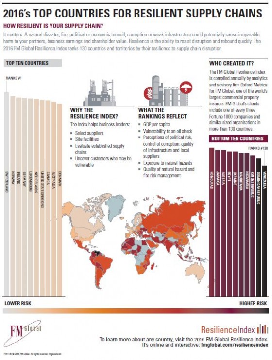
Switzerland, Norway Rank Highest in Supply Chain Resilience

Plummeting oil prices, natural catastrophes and political disruption in a borderless business environment are some of the threats to the resilience of countries that can impact supply chains, according to the 2016 FM Global Resilience Index, which aggregates data to help companies identify their key supply chain risks. The Index ranked the resilience of 130 countries to supply chain disruption based on drivers in three categories: economic, risk quality and supply chain factors.

This year’s top-rated country, Switzerland, traded places with Norway—a reflection of Norway’s drop in oil revenue at a time of falling crude oil prices. Rounding out the top 10 in the Index, in descending order, are Ireland, Germany, Luxembourg, the Netherlands, the central United States, Canada, Australia and Denmark.

The lowest-ranked country in 2016 is Venezuela (ranked 130) for the second year in a row. It is followed in ascending order by the Dominican Republic, Kyrgyz Republic, Nicaragua, Mauritania, Ukraine, Egypt, Algeria, Jamaica and Honduras.

For the second consecutive year, Ukraine (ranked 125, down from 107) was among the countries with the biggest drop, reflecting the high degree of tension the remains within the country as well as with Russia (ranked 75).

FM Global also noted:

Venezuela’s position at the bottom reflects its exposure to the natural hazards of wind and earthquake, perceptions of its lack of control of corruption and poor infrastructure and its ill-perceived local supplier quality.

France (ranked 19) and the United Kingdom (ranked 20) retained their positions from last year, while Germany (ranked 4) rose by two places.

The United States is segmented into three regions to reflect disparate natural hazards exposure:

Region 1, encompassing much of the East Coast, is ranked 11 in the Index.

Region 2, primarily the Western United States, is ranked 21.

Region 3, which includes most of the central portion of the country, is ranked 7 in the Index.
FM Global-infographic

Japan Earthquake Causes Parts Shortage, Closing 4 GM Plants

The earthquake in Japan earlier this month has impacted the supply chain of General Motors, causing four plants in North America to close temporarily because of a shortage of parts from Japan, the company reported.

GM said in a statement that its manufacturing operations are expected to be down for two weeks beginning April 25 in Spring Hill, Tennessee; Lordstown, Ohio; Fairfax, Kansas andGM logo the Oshawa Flex Assembly in Canada.

The temporary adjustment is not expected to have “any material impact on GM’s full-year production plans in North America,” GM said. In addition, the company “does not expect a material impact to its second quarter or full-year financial results for GM North America.”

Japan’s Kyushu Island was rocked by a 7.0 temblor on April 16, killing 58 people and injuring about 900, according to AIR Worldwide. The quake was the strongest to strike Japan since 2011, when a massive 9.0-magnitude offshore earthquake unleashed a tsunami that killed 18,000 people in the country’s northeast and triggered meltdowns at a nuclear power plant in Fukushima, the New York Times reported.

AIR said the earthquake is expected to result in insured losses between $1.7 billion and $2.9 billion. Those losses only reflect insured physical damage to onshore property (residential, commercial/industrial, mutual), both structures and their contents, from ground shaking, fire-following and liquefaction, AIR said.

The Japan Fire and Disaster Management Agency (FDMA) estimates that more than 3,900 residences and 120 non-residential buildings were damaged or destroyed, a number of mudslides resulted, and 14 fires were attributed to the temblors.

On the same day, April 16, a 7.

8 earthquake struck the central coast of Ecuador, killing 570 people and injuring more than 4,700. AIR estimates losses from that quake between $325 million and $850 million. More than 1,100 buildings are reported to have been destroyed and more than 800 damaged.

Even though they happened just hours apart, the two quakes are not related. The Times reported:

Are the two somehow related?

No. The two quakes occurred about 9,000 miles apart. That’s far too distant for there to be any connection between them.

Large earthquakes can, and usually do, lead to more quakes — but only in the same region, along or near the same fault. These are called aftershocks. Sometimes a large quake can be linked to a smaller quake that occurred earlier, called a foreshock. In the case of the Japanese quake, seismologists believe that several magnitude-6 quakes in the same region on the previous day were foreshocks to the Saturday event.

Houston Faces ‘Largest Flooding Event Since Tropical Storm Allison’

Historic flooding has left the Houston metropolitan area inundated once again this week, killing at least seven people, flooding 1,000 homes and causing more than $5 billion in estimated damages in Harris County alone. Gov. Greg Abbott declared a state of disaster for nine counties in and around the Houston area. The widespread nature of the disaster prompted the city of Houston to call this the largest flood event since Tropical Storm Allison, which devastated southeast Texas in 2001, causing $9 billion in damage and $1.1 billion in insured losses.

According to Harris County Judge Ed Emmett, about 240 billion gallons of rain fell on the Houston area this week. That’s the equivalent of 363,400 Olympic-size swimming pools, CNN reported. After 10 inches of rainfall fell in six hours Sunday night into Monday, powerful, slow-moving thunderstorms had paralyzed the region Monday, but storms continued through Wednesday.

Having some of the hardest rainfall overnight helped a bit to mitigate the dangers this week. While this made it difficult to predict, it allowed people to better make choices about going out, as opposed to last year’s floods around Memorial Day, Emmett told the Houston Chronicle. Nevertheless, emergency crews made more than 1,200 high-water rescues, many residents had to evacuate to shelters, and for those who were able to shelter in place, 123,000 homes had no power at the height of the flooding. Officials have also expressed concern about two local dams that have been rated “extremely high risk and are at about 80% capacity, but they are not in immediate danger of failing.

As I wrote in Risk Management last year, the city’s rapid urbanization and approach to land development have made it extremely vulnerable to flooding perils because there is little land surface that can absorb water in foul weather. Rivers, bayous and other receptacles for runoff are easily overwhelmed and take a considerable amount of time to return to normal levels, making the heavy, concentrated, sustained rainfall seen this week even more dangerous in such an urbanized setting. Last May, record rainfall and severe thunderstorms caused tremendous damage across Texas and Oklahoma, killing 32 people and flooding more than 5,000 homes in the metro regions of Houston, Austin and Dallas.

With this latest storm, Houston again offers a powerful reminder about the natural catastrophe perils compounded by urbanization and the need to prepare, both in the form of routine disaster preparation and urban planning. From the August issue of Risk Management:

The city has invested hundreds of millions of dollars to battle the effects of urbanization. On Buffalo Bayou alone, for example, flood control efforts totaling half a billion dollars in the past decade have included bridge replacements, the addition of detention ponds for runoff, and creation of green spaces that serve as parks in normal weather while offering more land surface that can absorb water in foul weather.

But the investments are not enough. “Houston may be doing things to try to improve…but there’s a long history of pre-existing stuff that is still there,” Walter Peacock, an urban planning professor at Texas A&M and director of the school’s Hazard Reduction and Recovery Center, told Time. “Think about every time you put in a road or a mall and you add concrete—you’ve lost the ability of rain to get into the soil and you’ve lost that permeability. It’s now impermeable, and therefore you get more runoff.”