Want to scan your crypto wallet for risks? Check: AML crypto BTC, USDT, ETH. Checking cryptocurrency wallets for dirty money.

Lava Threatens Hawaii’s Land, Economy and Ecology

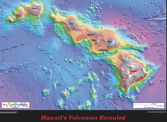
Activity from the Kilauea volcano on the island of Hawaii, in Lava Zones 1 and 2—deemed the most dangerous of the island’s nine zones—continues into its third week. As previously reported, aftershocks, lava flow and lingering hazardous fumes in Lanipuna spilled into nearby areas. About 1,800 people living in surrounding neighborhoods were ordered to be evacuated earlier this month by Hawaii County. The one serious injury reported was of a man sitting on this front porch, who sustained a leg injury caused by lava splatter.

Experts warn that more powerful explosions may follow the 30,000-foot ash cloud that engulfed the sky on May 17. Since then, breathing masks have been distributed to local residents and workers.

On May 18, the Hawaii Tourism Authority (HTA) issued a press release aiming to quell fears about safety on other parts of the island. The statement explained that the only affected region is “a remote area along the Lower East Rift Zone on the island, Kilauea Summit and surrounding areas.” The steam and ash outbursts from Halema’uma’u crater are occurring in Hawaii Volcanoes National Park, which is about 40 miles from the Lower East Rift Zone. This is a natural occurrence as rocks fall into the crater and magma interacts with groundwater.

An “aviation red alert” was issued last week due to the potential that aircraft routes could be impacted by the ash, but flights and normal operations have apparently not been impacted and the HTA maintained that there is “no reason for visitors planning a trip to the Hawaiian Islands to change or alter their leisure or business travel plans.”

Reports indicate, however, that as of last week, cancellations from May through July added up to at least $5 million and bookings for hotels and other outdoors activities have declined by 50%.

And while the tourism and transportation industries are integral to the state’s economy, the risk to its ecology is becoming more evident and immediate. In addition to the falling ashes, air near the site contains sulfur dioxide, which some breathing masks cannot protect against.

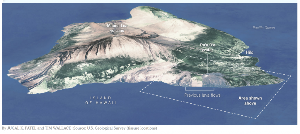
Several fissures combined created two lava flows that have entered the ocean off Highway 137 near MacKenzie State Park, according to the Island of Hawaii’s Civil Defense. Highway 137 is a critical stretch along the coast that is the site of several problems for residents. A two-story lava wall emerged on parts of the highway, essentially cutting off a portion of the escape and evacuation route. Authorities have since opened an alternate escape route via Highway 11, which was blocked by almost a mile of lava in 2014.

The lava oozing into the Pacific Ocean has short- and long-term effects on the local ecology. While it is certain to harm or repel marine life, the chemical reaction when mixed with water also affects the air.

A Hawaii county spokesman said recently:

“The lava has entered the ocean. Be aware of the laze (lava haze) hazard and stay away from any ocean plume. Laze is formed when hot lava hits the ocean sending hydrochloric acid and steam with fine glass particles into the air.

As one can imagine, since the laze is in the air, lungs, eyes and skin are particularly susceptible to irritation and it can change direction quickly since it travels with the wind.”

Information on ash hazards and how to prepare for ashfall can be found here.

Although the K volcano has been active for decades, this most recent surge in activity could be attributed to the 6.9-magnitude earthquake on May 4, the strongest quake to hit Hawaii in more than 40 years. The earthquake was one of hundreds to be felt recently on the Big Island, although none of them caused any notable threat to life or property.

Implications of Flood Risk

Across the vast geography of the United States, flood is no stranger to any of the states. From the March 2018 Nor’Easters that slammed the East Coast to the numerous storms and hurricanes that have swept across the country, both coastal and non-coastal regions are all at risk of flood.

FEMA reports that 98% of the U.S. counties have been impacted by a flooding event in the past, and 2016 and 2017 are examples of both the frequency and severity that the peril poses. According to Munich Re’s Geo Risks Research, there were more floods in the U.S. in 2016 than any year on record. Hurricane Harvey, the eighth named storm in the 2017 Atlantic hurricane season, caused large flood losses and is reported as the second costliest hurricane in U.S. history after Hurricane Katrina. Major losses from Katrina were caused by flooding due to levee failure.

The National Flood Insurance Program (NFIP) was enacted by Congress with three main pillars: affordable insurance, floodplain management and flood mapping.  Since its inception, the program has helped thousands of home owners with total claims exceeding $65 billion. The NFIP’s role in aiding homeowners was evident during the weeks and months following Hurricane Harvey. According to FEMA, as of January 2018, more than 91,000 NFIP policyholders had filed claims for Hurricane Harvey, and FEMA has paid more than $7.6 billion in losses to those policyholders. the economic losses of Hurricane Harvey, however, are likely to reach $85 billion. Even after considering the commercial insured losses, the gap between the insured and economic losses, known as the “protection gap,” is huge.

Based on events like Hurricane Harvey and Superstorm Sandy it is likely that as many as 80% of the homes in Houston were not insured for flood. In fact, according to the Insurance Information Institute, only about 12% of the home owners in the United States purchase flood insurance; this statistic is even lower in inland states. The number of NFIP policies in the Mississippi River states (which excludes Louisiana) is about 5% of the total NFIP program. Using current building stock data from Homes.com, this would make the purchase rate for flood insurance in the Mississippi states at less than 2%.

Why is there such a large protection gap and why is it important to narrow this gap?

A Floodzonedata.us study by the New York University (NYU) Furman Center found that there are about 6.9 million housing units within the 100-year flood plain as defined by FEMA. According to a February 2018 scientific study in IOPscience, however, “Estimates of present and future flood risk in the conterminous United States,” the actual number of exposed houses could be as high as 15.4 million. In addition, a September 2017 audit by the Department of Homeland Security Office of Inspector General noted that, as of December 2016, only 42% of FEMA’s flood maps are up to date and valid. Both Superstorm Sandy and Hurricane Harvey demonstrated several instances of FEMA maps being inadequate to evaluate the extent of flooding.

Extreme events like Harvey should be viewed as an opportunity for resilience initiatives.  Jeffrey Heberg, Chief Resilience Officer for New Orleans, notes that the key to resilience is insurability. In fact, studies highlight the importance of high insurance penetration and the correlation to strong resilient countries.

The stark contrast in the insurance penetration between Chile, Haiti and New Zealand provides an example of the impact the insurance industry can have towards financing the losses from major catastrophes. Following earthquakes in 2010, New Zealand and Chile showed faster recovery due to high insurance penetration and thus the ability to absorb losses, whereas Haiti went through a very slow recovery process due to the lack of catastrophe (re)insurance.

While insurance is an important factor, financial resilience through insurance is not enough. There is a further need for a comprehensive approach to mitigate severe natural catastrophes. This is when public private partnerships (P3s) play a crucial role. In New Zealand, the government-owned earthquake commission, with reinsurance in the global market, resulted in insurance penetration of up to 80%. A similar example of P3 in the United States is the reinsurance protection sought by FEMA to reinsure the NFIP against extreme events.

Public private partnerships rely on the government’s ability to ensure adequate loss prevention, build physically resilient structures and implement forward-looking municipal planning (such as futuristic view of flood maps and flood plain management). If people reside in and build more resilient structures, not only can it help save lives, but the cost of insurance could be less, and the probability of loss and recovery time will be less for communities.

It is not only important to focus on building resilient communities to help protect them from natural catastrophes, it is now becoming a crucial requirement for cities and states.  Standard & Poor’s emphasizes the importance of disaster insurance arrangements on sovereign financial resilience. The September 2015 Standard & Poor’s Rating Report notes that a lack of insurance coverage for significant catastrophic events could negatively impact sovereign ratings resulting in a downgrade. As recent as November 2017, Moody’s reported the incorporation of climate change into its credit ratings for state and local bonds. This would mean that communities, cities and states may get downgraded unless they show sufficient adaptation and loss mitigation strategies.

The time for resilience is now. As geographic regions that were once sparsely populated are now filled with burgeoning cities there is so much more at risk from today’s extreme weather events. Insurance can play a role in helping communities recover. Insurance alone, however, is only a partial solution. We also need to build resilient communities to help mitigate the damage caused by flood.

Hawaii Volcanic Activity Reinforces States’ Need for Catastrophe Planning

Recent volcanic activity in Hawaii has turned national attention to emergency preparedness planning. As previously reported, the Kilauea eruption lessened but caused aftershocks, lava flow and lingering hazardous fumes in nearby areas. About 1,800 people live in the area, which was ordered to be evacuated last week by Hawaii County. No deaths or injuries have been reported.

On May 9, two more actively erupting fissures from the Kilauea volcano opened near Lanipuna, a neighboring community to the already affected Leilani Estates. Fox News reported that first responders went door to door to ensure everyone in the community was safely evacuated. At least 14 fissures are now open from Kilauea—considered one of the world’s most active volcanoes—with some releasing toxic gases and others spewing lava, at times at least 200 feet into the air.

Hawaii Gov. David Ige signed a Presidential Disaster Declaration request, asking President Donald J. Trump to declare the state a major disaster as a result of the ongoing seismic activity. Gov. Ige also requested assistance from the Federal Emergency Management Agency (FEMA), citing the unpredictable nature of the volcano, the number of structures destroyed, and the fact that residents may be unable to return to their homes for an undetermined amount of time.

Gov. Ige said in his Presidential Declaration request:

As more fissures open and toxic gas exposure increases, the potential of a larger scale evacuation increases. A mass evacuation of the lower Puna District would be beyond current county and state capabilities, and would quickly overwhelm our collective resources. Federal assistance would be necessary to enable us to successfully conduct such large-scale operations.

CBS reported that many people in the affected communities live in “lava zone one,” a high-risk area. Lava insurance doesn’t exist and homeowners’ insurance is very expensive, so some are going to be left on their own to try and rebuild.

With all these events, however, visitors to Hawaii.gov will find very little, if anything about the volcanic eruption on the state’s homepage [see screenshot]. Instead, there is much about the mild weather and announcements of a groundbreaking ceremony for a road pavement rehabilitation and the modernization of its payroll system. All-in-all, it’s difficult for the public to gage imminent dangers, such as the dangers of molten lava on the site. Visitors, as well as residents, need to navigate to the Residents Page to find the Emergency Information.

What Other States Can Learn
While volcanic eruptions may be relatively infrequent in the continental United States, the threat exists: There are 169 active volcanoes in the U.S., and 54 of them are considered high threats by the United States Geological Survey (USGS). Washington is one state that is proactive in its planning, and May just happens to be when it observes Volcano Preparedness Month. Washington has had five active volcanoes: Mount Rainier, Mount Baker, Mount Adams, Glacier Peak, and Mount St. Helens. The latter volcano erupted in 1980 and demonstrated the disaster potential of volcanoes, causing an estimated $31 million in insured losses. That eruption killed 57 people and left dramatic changes to the landscape. It undoubtedly impacted state officials, who regularly include environmental and natural disasters in their strategic plans.

King County, Washington is in close proximity to these volcanoes and has a page dedicated to volcanic activity. It explains how its active volcanoes pose different threats from Hawaii’s:

Unlike Hawaiian volcanoes that ooze molten lava, volcanoes in the Pacific Northwest are known for sending choking ash, hot rocks, and poisonous gases high into the sky. Lahars, which are deadly mixes of hot mud, ash, and other debris, are also a big concern.

It also advises how residents and businesses should prepare and react in the event of an eruption. After ashfall:

  • Wear goggles to protect your eyes and long-sleeved shirt and pants to protect your skin.
  • Clear roofs and rain gutters of ashfall. Ashfall is very heavy and can cause buildings to collapse. Use extreme caution when working on a roof.
  • Avoid running vehicle engines. Driving can stir up volcanic ash that can clog engines, damage moving parts, and stall vehicles.
  • Avoid driving in heavy ashfall unless absolutely required. If you must drive, keep the speed down to 35 MPH or slower. Be prepared to change oil, oil filter, and air filters frequently (every 50 to 100 miles in heavy dust and every 500 to 1,000 miles in light dust).
  • As much as possible, keep ash out of buildings, machinery, air and water supplies, downspouts, storm drains, etc.

In 2017, King County co-hosted a climate change resiliency summit with the United Kingdom’s consulate to assess the physical geography and explore better emergency preparedness plans.

Risk Manager of the Year Honor Roll Member Jennifer Hills already had natural disasters on her radar. The director of risk management for King County, Hills is continually learning about the practical threats of a natural disaster and the county’s resiliency.

“We’re now looking at where emergencies and climate change should be on our risk register,” she told Risk Management magazine earlier this year, adding that she frequently collaborates with the county’s climate change and emergency management offices. “There’s a lot we’re understanding about King County’s exposures to natural disasters and we’re planning for those risks and how to mitigate them.  There’s a lot of untapped resources we may need to open.”

Hawaii Volcano Subsides, Aftershocks Continue

Volcanic activity from the Kilauea eruption in Hawaii has lessened, although aftershocks, lava flow and hazardous fumes continue in some areas, the Hawaii Volcano Observatory reported yesterday. Aftershocks from Friday’s magnitude-6.9 earthquake also continue, with more expected, including larger aftershocks potentially producing rockfalls and associated ash clouds, according to the United States Geological Survey.

So far 12 fissures have emerged, sending lava into the Leilani Estates and Lanipuna Gardens subdivisions, where 35 structures have been destroyed, according to the Hawaii County Civil Defense Agency. About 1,800 people live in the area, which was ordered to be evacuated last week by Hawaii County. No deaths or injuries have been reported.

Authorities began allowing residents of Leilani Estates to retrieve their belongings on Sunday, while Lanipuna Gardens remained closed because of dangerous volcanic gases. The civil defense agency had previously warned about the threat of high levels of deadly sulfur dioxide gas in the area—released from magma no longer contained by the earth’s pressure.

According to Munich Re, about 550 volcanoes are classed as being active worldwide, with between 50 and 65 of them erupting annually. Active volcanoes in the United States are found mainly in Hawaii, Alaska, and the Pacific Northwest. The 1980 eruption of Mount St. Helens in Washington state demonstrated the disaster potential of volcanoes, causing an estimated $31 million in insured losses. The eruption killed 57 people and left dramatic changes to the landscape.

buy metformin online cphia2023.com/wp-content/uploads/2023/08/jpg/metformin.html no prescription pharmacy

The Insurance Information Institute lists the damages caused by volcanos which are, and are not, covered by insurance:

What is covered

  • Most home, renters and business insurance policies provide coverage for property loss caused by volcanic eruption when it is the result of a volcanic blast, airborne shockwaves, ash, dust or lava flow. Fire or explosion resulting from volcanic eruption also is covered.
  • Homeowners and business owners’ policies also provide coverage for property damage, vandalism or theft due to looting if the occupants are displaced.
  • There is typically a 72-hour waiting period before business interruption coverage kicks in.
    buy lariam online cphia2023.com/wp-content/uploads/2023/08/jpg/lariam.html no prescription pharmacy

  • Damage to vehicles caused by lava flow is covered under your auto insurance policy if you have comprehensive coverage, which is optional. Direct, sudden damage to engines from volcanic ash or dust is also covered under most policies.

What is not covered

  • Most home, renters and business insurance policies do not cover damage from earthquake, land tremors, landslide, mudflow or other earth movements regardless of whether or not the quake is caused by or causes a volcanic eruption. Earthquake insurance is available from private insurers as an endorsement to a homeowners policy, and in California from the California Earthquake Authority, a privately funded, publicly managed organization.
  • Damage to land, trees, shrubs, lawns, property in the open or open sheds (or the contents of those sheds) is typically not covered.
  • The cost to remove ash from personal property is generally not covered unless the ash first causes direct physical loss to personal property. There is also no coverage to remove ash from the surrounding land.
  • Business interruption insurance does not kick in unless you have an endorsement to your business owners policy for earthquake and volcanic eruption and:
    • there is direct physical damage resulting in suspended operations;
    • there is physical damage to other property that prevents customers or employees from gaining access to the business;
    • the government shuts down the area, preventing customers or employees from gaining access to the premises.
  • The damage that occurs to homes, businesses or vehicles over time due to volcanic dust is not covered under most policies.

Volcanic effusion (i.e. volcanic water and mud) is not covered under a typical homeowners, renters or business insurance policy. However, it is covered by flood insurance, available through the National Flood Insurance Program.