Игроки всегда ценят удобный и стабильный доступ к играм. Для этого идеально подходит зеркало Вавады, которое позволяет обходить любые ограничения, обеспечивая доступ ко всем бонусам и слотам. LeapWallet is a secure digital wallet that enables easy management of cryptocurrencies. With features like fast transactions and user-friendly interface, it's perfect for both beginners and experts. Check it out at leapwallet.lu.

Natural Barriers Promote Coastal Resilience, Reduce Costs

WetlandsNEW YORK—Hurricane Irene and Superstorm Sandy had devastating impacts on the northeast coastline, debilitating parts of New York and New Jersey. While also in the path of the storms, Delaware saw minimal impact, which the state’s former head of natural resources and environmental control, Colin O’Mara, attributed to its conservation efforts.

Now president and chief executive officer of the National Wildlife Federation, O’Mara spoke at the New York Recovery and Resilience Leadership Forum here June 2, explaining that the state had been building up natural barriers and testing its resilience with various resources.

“During the storm we were checking sandbags and making sure systems were in place and I was wondering if these systems were going to hold,” he said. “What we found was that the system did work.

online pharmacy augmentin with best prices today in the USA

” He noted, “One of the reasons you haven’t heard much about what happened in Delaware, compared to New Jersey and New York, is the state’s investments in wetlands, living shoreline projects and oyster beds. These natural systems can absorb the shock of crashing waves and absorb water.”

A living shoreline is a habitat-friendly alternative to rip rap, bulkhead or stone revetments, creating wetland habitat that supports blue crabs, oysters, fish, birds and plants. They can also stop erosion, increase water quality and protect the shoreline from erosion, according to the state of Delaware’s website.

A number of municipalities across the country are making significant advances in natural infrastructure, O’Mara said, “and you are not seeing big taxpayer bailouts of those communities because these systems work.”

At the same time, he noted, many areas do not encourage these types of investments. “In fact, there are a number of policies that are actually putting people in harm’s way,” he said. “We’ve been trying to think through how to have traditional market forces work to the advantage of resilience, instead of having a massive bailout after an event, which is a liability to the taxpayer.

online pharmacy renova with best prices today in the USA

Conversations about mitigating with natural resources, however, often get nowhere because people believe their insurance programs will bail them out. “Because of government programs, people are actually paying so much less than the insurance value they are receiving, that natural resources as a solution will lose,” O’Mara said. As a result, “All of a sudden that coast seems more developable because the landowner developing it isn’t actually bearing the cost.

online pharmacy imuran with best prices today in the USA

” The real problem is that, after the money has been made and a homeowner is living in the house, the risk is still there. “So you’ve privatized the problem, but you have socialized all of the risk,” he said.

Instead, O’Mara believes it is critical that information about the real costs of destroying a dune, along with the protections it brings be available. “This isn’t an easy conversation, but it is actually an area of commonality,” he said. “Whether you want to reduce government spending, reduce liability or foster more private sector activity, this is an area that shouldn’t be partisan at all.”

Projects of this nature are currently in the works in New York City; Cape May, New Jersey; and Boston, Massachusetts. Such spending on the front end produces much higher savings in the long run, O’Mara said, noting that putting natural resources to work can lower insurance rates and generate private sector involvement.

“We can do things a lot smarter and be a lot safer than we are right now,” O’Mara said. “This should be as bipartisan as anything we do in this country. The economics make sense, the science makes sense and the social science makes sense.” After all, at the end of the day, “people just want to be safe,” he said.

California’s New Localized Water Controls a Step Forward

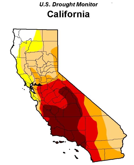
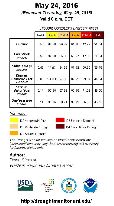
With higher levels of rain and snowfall over the winter, California’s water situation has eased in some areas, prompting the state to initiate new water conservation rules, adopted on May 18 and in effect June 1 through January 2017. The regulations give control over water usage to local communities, which means more restrictions in some areas than in others. In Northern California, winter precipitation has filled some reservoirs, while drought conditions persist in Southern California.

The previous rule—enacted in April 2015 by Gov. Jerry Brown, who issued an Executive Order mandating a 25% reduction of urban water usage from 2013 levels over a nine-month period—saw a savings of about 424 billion gallons. That followed a failed year-long effort to achieve a voluntary 20% reduction in water usage, with statewide conservation results averaging between just 7% and 12%.

The State Water Resources Control Board explained that the new approach replaces the percentage reduction-based water conservation standard with a localized approach. The emergency regulation requires that urban water suppliers ensure that at least a three year supply of water would be available to their customers in case of drought conditions. Suppliers that would face shortages under three additional dry years are now required to meet a conservation standard equal to the amount of a shortage. A water agency that projects it would have a 10% supply shortfall, for example, would have a mandatory conservation standard of 10%. The regulation also makes previously passed water-wasting rules permanent, including no hosing of sidewalks, washing cars without a hose nozzle, or watering lawns within 48 hours of measurable rainfall.

“El Nino didn’t save us, but this winter gave us some relief,” Water Board Chair Felicia Marcus said in a statement. “It’s a reprieve though, not a hall pass, for much if not all of California. We need to keep conserving, and work on more efficient practices, like keeping lawns on a water diet or transitioning away from them. We don’t want to cry wolf, but we can’t put our heads in the sand either.”

Will Sarni, director and practice leader of water strategy at Deloitte, agrees with the direction the state is taking on conservation.

While it may appear that restrictions are being eased, which could send the message that things are going back to business as usual, “It’s not business as usual, but local entities are being given more control,” Sarni said. “My view is that water is ultimately a local issue, so providing greater flexibility and decision-making at the local level that aligns with an overall strategy within the state, or nation, makes sense.”

The model of local management actions that roll up to a regional entity have successfully been adopted in other parts of the country, he said, explaining that states do work together. One example is the Delaware River Basin Commission, which is an entity that has a say in how water is managed in the Delaware River. Other examples include the Great Lakes Commission and the Colorado River Compact. “So cooperating on water is actually more common than not,” Sarni said.

Drought1

Drought 2

Fort McMurray Wildfire Insured Losses Up to $6.9 Billion

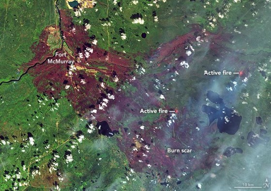
Ft-McMurray map

NASA Fort McMurray wildfire map

Insured loss estimates from the wildfire in Fort McMurray, Alberta, Canada, are projected between $3.4 billion and $6.9 billion, catastrophe modeling firm AIR Worldwide reported. Officials are still in the early stages of assessing damage caused by the wildfire that began on May 1 and quickly spread from forests to neighborhoods, outpacing local firefighters’ capacity to contain it. According to AIR, the Fort McMurray wildfire is the costliest natural disaster in Canada’s history.

The fire had initially moved away from Fort McMurray, but shifted back toward the city this week, causing evacuations for the second time. About 500 to 600 people were evacuated from four small work camps, Alberta Premier Rachel Notley said in a news conference on Monday.

The fire is still uncontained and, as of May 14, had covered nearly 600,000 acres, mainly in wildlands and away from population centers. Winds are now calmer and temperatures have lowered, with considerable cloud cover and a possible shower expected—all of which are expected to help firefighting efforts.

The fire’s new threat reversed earlier efforts to return local oil sands projects to full operation, the New York Times reported. The highway through Fort McMurray was reopened several days ago to allow workers to return to the work sites, but was closed again on Monday.

Premier Notley said that five things need to be in place before residents may reenter Fort McMurray:

  • Wildfire is no longer an imminent threat to the community
  • Critical infrastructure is repaired to provide basic services
  • Essential services, such as fire, EMS, police and health care are restored to a basic level
  • Hazardous areas are secure—100 truckloads of fencing are being sent to Fort McMurray
  • Local government is re-established

Firefighting crews are still trying to put out fires in the northern part of the city. Fort McMurray’s airport, water treatment plant, municipal building, hospital and all functioning schools were safeguarded, according to AIR. The airport continues to be used only for wildfire aircraft operations, however, and is closed to commercial and private aircraft until further notice. Current information suggests that a total of more than 2,400 structures have been lost—roughly 10% of the total number.

AIR said its loss estimates capture residential, commercial and automobile losses, as well as business interruption losses, except those related to the oil industry. AIR derived its loss estimates based on high-resolution Industry Exposure Database (IED) for Canada and damage ratios estimated from satellite imagery and experience from claims adjustments for historical U.S. wildfires. IED exposure values included in loss estimates have been trended to Jan. 1, 2016.

The wildfires in Canada illustrate a continuing trend of increasingly severe wildfires that caused a record 10.1 million acres to be burned in the United States in 2015, surpassing the previous high of 9.8 million acres in 2006, Mark Crawford reported in last month’s issue of Risk Management. It was the fourth year in the past decade in which more than nine million acres burned. According to the U.S. Forest Service, the 2015 wildfire season was the costliest on record, with more than $2 billion spent fighting fires.

October 2015 the Warmest Ever Recorded

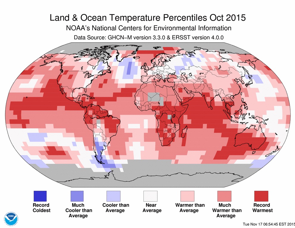
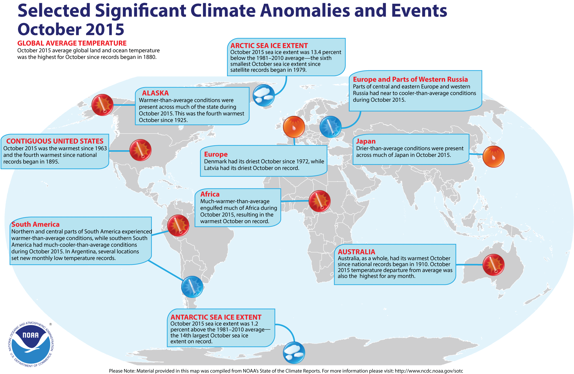
It isn’t just your imagination: October 2015 was the warmest on record worldwide, and saw the greatest above-average deviation for any month. According to the National Oceanic and Atmospheric Administration, the average temperature across global land and ocean surfaces was 1.

buy zantac online healthymomsandbabes.org/wp-content/uploads/2023/10/jpg/zantac.html no prescription pharmacy

76 °F above the 20th century average, surpassing the previous record set last year by 0.36 °F. The globally-averaged land surface temperature was 2.39°F above the 20th century average—the highest for October in 136 years of NOAA records.

buy mobic online healthymomsandbabes.org/wp-content/uploads/2023/10/jpg/mobic.html no prescription pharmacy

NOAA land and ocean temp percentiles

October was also the warmest month ever compared to average, out of a total of 1,630 months. What’s more, NOAA reports, eight of the first 10 months of the year have been record warm for their respective months—also a record number of broken records. Globally-averaged land surface and sea surface temperatures have been 1.55 °F and 2.30 °F above average, respectively, surpassing all previous records. With many months setting record high temperatures by unprecedented margins, NOAA said in August that there was a 97% chance that 2015 would secure the title of the warmest year on record, and it remains solidly on track.

In early November, the Met Office, Britain’s national weather service, and NASA both reported that the Earth’s average temperature is likely to rise 1 °C above pre-industrial levels for the first time by the end of 2015. This milestone is significant since it marks the halfway point to two degrees Celsius, the internationally accepted limit for avoiding the worst consequences of climate change, the Washington Post reported. Since 2000, global monthly heat records have been broken 32 times, yet the last time a monthly cold record was set was in 1916, according to CBS News.

Some of the heat is likely due to a strong El Nino event in the Eastern Pacific that continues to gather strength.

buy zocor online healthymomsandbabes.org/wp-content/uploads/2023/10/jpg/zocor.html no prescription pharmacy

This year’s El Nino is already one of the three strongest ever seen, CNN reports, but cannot account for all of the year’s warmth, as 13 of the 15 warmest years on record have occurred since 2000. Rather, it is the combination of long-term warming and the strong El Nino pushing Earth toward its second consecutive warmest year on record.

According to Aon Benfield’s October 2015 Catastrophe Report, there were three billion-dollar weather-related disasters in October: flooding in South Carolina with economic losses of at least $2 billion, $4.2 billion in damage from Typhoon Mujigae in China, and $1 billion in damage from flash flooding in France. The firm estimates worldwide economic losses from October to total more than $10 billion. There have been 21 billion-dollar weather events through October 2015, Aon reported, on pace for a lower total than the annual average of 28.

Check out the infographic below for more of the major climate anomalies and events from October 2015:

NOAA october climate anomalies