Игроки всегда ценят удобный и стабильный доступ к играм. Для этого идеально подходит зеркало Вавады, которое позволяет обходить любые ограничения, обеспечивая доступ ко всем бонусам и слотам.

Q&A: Resiliency in India

The 2018 Lloyd’s City Risk Index was analyzed during the RIMS Risk Forum India in Mumbai, and it notes a possible turning point for the subcontinent’s cities regarding resiliency. In short, Indian cities were rated as weak, but recent government and public investments and campaigns that focus on strengthening infrastructures and people may strengthen those assessments.

During a November 14 morning session, “Assessing the Impact of Natural and Man-made Threats on India’s Economy,” Shankar Garigiparthy, country manager and CEO of Lloyd’s India discussed how much economic output (GDP) cities in India could lose annually as a consequence of various types of rare risk events – such as the Kerala floods this past July – or from more frequently occurring events such as cyberattacks.

He discussed with Risk Management Monitor reasons why he is hopeful for a resiliency turnaround in India and how the combined wills of the government, media, public and business can strengthen the country’s infrastructures and ultimately, its risk ratings.

RMM: How do India’s cities rank in Lloyd’s City Risk Index?

SG: Lloyd’s City Risk Index was published three months ago and we researched 279 cities. We found that a vast majority of cities within the subcontinent of India have been rated as very weak from a resilience point of view. They are at high risk for flood, geopolitical security, market crash, just to name a few.

RMM: What steps are being taken to improve the collective resiliency?

SG: What we have seen in last three or four years is a significant level of investment from the government in terms of building infrastructure. It’s been in the form of roads, bridges, railways, ports, and airports, there has been a significant level of investment. And it seems there is more to come. In the budget, the government has announced more – which is encouraging to see from an infrastructure-building point of view.

However, where we still see a bit of lack is in the area of insurance penetration in the country. That’s where I think insurance companies can be a useful partner and tool to mitigate some of the level of these risks.

buy imuran online https://ozgurmd.com/wp-content/uploads/2023/10/jpg/imuran.html no prescription pharmacy

RMM: Could this be a chance for insurers to get in on the ground floor of India’s improvement projects?

SG: Yes.

RMM: What incidents have influenced the government to act?

SG: The Chennai floods [in 2015] and the floods in Kerala [in July]. That was a once-in-a-hundred-years occurrence. The entire state was flooded, which I think was the first of its kind. It was completely underwater.

Similarly, the Chennai floods marked another major event. Since then, monsoon has happened but the level of flooding has been managed pretty well.

In the session, we examined the Mumbai floods in 2005. And even last year, there was flooding here for a day, but within a day the water receded pretty quickly and was pumped out. The machinery kicked in and we were able to get out of it pretty well.

RMM: What led to that success?

SG: It was a combination of low tide and the government investing in the necessary pumping mechanisms to actually pump the water back into the sea, and unclog some of the stormwater drains as well. Steps are being taken, slowly but steadily.

RMM: What other institutions are taking measures to build resiliency?

SG: There are a few companies [which I won’t name] that are leading the way and it is encouraging to see that.

The media is also equally playing a fairly significant role as well. That’s also helping because public awareness is something that is critical. The media is raising awareness in terms of the importance of protecting your infrastructure and environment and the need for trees and planting.

RMM: Would you agree that the will to change and improve existing infrastructures is as important as the funding?

SG: I think it’s all there. The government has shown willingness to improve infrastructure. The people have demanded it, so there is a push and a pull coming from both sides. And we are seeing that development happen. Compared to where we were five or ten years ago and where we are now, there’s been a massive change.

There is still more that can be done. I’m not saying that we’re there yet. But it’s not an easy thing, as well.

Given India’s geography and how the political scenario is within the country, we will always be exposed to natural catastrophes.

buy imodium online https://ozgurmd.com/wp-content/uploads/2023/10/jpg/imodium.html no prescription pharmacy

Flooding is going to be a constant phenomenon for us.

There is investment being done but it’s patchy. In some states there has been fantastic infrastructure investment and in others, less so. I think that has got to be addressed and that’s where the public [should be] demanding more actions there, where infrastructure investment has not been up to the mark.

Amid Wildfires, California’s Emergency Warning Systems Take Heat

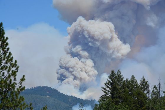
Overnight, the Mendocino Complex Fire in Northern California expanded far enough to oust the 2017 Thomas Fire as the largest wildfire in the state’s history. Comprising two joined fires, the Mendocino Complex Fire has burned through 443 square miles in the area north of San Francisco. As of Tuesday morning, the fires burned more than 140 structures, including at least 75 homes, and was 30% contained.

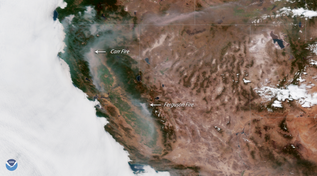
But California’s residents and businesses still should be on alert, as the incendiary activity doesn’t end there. An unprecedented 14,000 firefighters are combating between 12 and 16 wildfires in the state, according to the Department of Forestry and Fire Protection. Particular emphasis is in Northern California, where the fires in Mariposa and Shasta counties continue to threaten residents, businesses, and emergency responders. For 26 days, the Ferguson Fire in Mariposa County has burned nearly 90,000 acres and caused two fatalities. The fire is having a huge impact on areas near and around Yosemite National Park, which alerted the public that it had closed all but two entrances and roads.

Redding, a city 150 miles north of Sacramento, is the site of the Carr Fire, which has been ablaze for two weeks. Weather.com reported that the fire has caused seven deaths and the destruction of nearly 1,600 structures, the majority of which are homes.

The city of Redding launched an interactive map that provides residents with images of neighborhoods so they can check the status of their homes. Reports indicate that more than 1,800 structures are still in the path of the fire.

Despite such technological advances, many residents have questioned the effectiveness of the state’s emergency notification system, which they rely on for evacuation notices.

The California Governor’s Office of Emergency Services currently uses an integrated California Public Alert and Warning System (CalPAWS) Plan to warn the public of danger.

Affected residents in several areas have claimed that they did not receive the CalPAWS evacuation order – including the great-grandmother who perished in the Carr fire in July with her two great-grandchildren. On Aug. 4, California Gov. Jerry Brown held a press conference in Shasta County to discuss the damage. But California’s emergency notification systems—and its unreliability in certain areas of the state—were a central focus of the conference.

Gov. Brown said he would consider legislation to improve alert systems, acknowledging local lawmakers’ proposals in an effort to create a statewide system that requires registration from all residents.

“I think we do need the best alert system we can get, and that’s what I would help the Legislature achieve,” Brown said, according to the Sacramento Bee. “There’s a lot of things we can do, and we can always do more …

given the rising threats on the changing of the weather, the climate.”

The Bee reported that a bill with adoption plans for a uniform alert system has been drafted:

The bill, Senate Bill 833, would require counties to automatically sign up residents for a uniform cell phone alert system. It would also fund a standardized system equipped to push out alerts on all forms of media—radio, television, electronic highway billboards and landlines. County emergency managers would be required to undergo annual training on the latest alert technology.

Under such a plan, which would utilize the federal Wireless Emergency Alerts system, they’d have to opt out rather than sign up voluntarily.

Furthermore, the governor said he hopes to overhaul the state’s 911 system, which would de-centralize the calls and notifications to ensure more accurate messaging.

Also on Aug. 4, the White House approved California’s request for a Presidential Major Disaster Declaration to help with the impacts of the wildfire in Shasta County.

“This is part of a trenda new normalthat we’ve got to deal with. We’re dealing with it humanly, financially and governmentally,” Gov. Brown said during a media briefing at the Carr Fire Incident Command Post in Anderson, California. “These kinds of horrible situations bring people together, regardless of the lesser kind of ideologies and partisan considerations.”

Calif. Carr Fire Claims 6 Lives

Just when it seemed like things couldn’t get any worse in California, the Carr wildfire ignited, claiming six lives so far. The fire in Northern California near the city of Redding has been burning since July 23 and is now one of the largest in the state.
Almost 90,000 acres have burned, destroying more than 500 homes and commercial buildings and damaging 135 structures. Firefighters, who are working 24- to 36-hour shifts with little rest in between, said they are making progress and are now on the offense rather than in a defensive mode.

“Although it’s too early for credible insured loss estimates, the current California wildfires could noticeably impact exposed insurers’ 3Q 2018 earnings,” KBW said in a statement today.

Wildfires are also burning in Mariposa County California. The Ferguson Wildfire has closed large parts of Yosemite National Park, the Risk Management Monitor reported. That fire began July 13 at about 8:30 p.

buy diflucan online achievephysiorehab.ca/wp-content/uploads/2023/10/jpg/diflucan.html no prescription pharmacy

m. and by July 15 had nearly doubled to 9,300 acres. By July 27 it had burned 45,000 acres and was contained 5%, according to NOAA.

buy sinequan online achievephysiorehab.ca/wp-content/uploads/2023/10/jpg/sinequan.html no prescription pharmacy

While authorities have not declared an official cause for that fire, Colin Gannon, senior data analyst at Four Twenty Seven, which studies the economic risk of climate change, said weather and environmental conditions are certainly contributing factors.

The Associated Press reported that hotter weather attributed to climate change dries out vegetation, allowing for more intense, faster-spreading wildfires. Another issue is expansion of subdivisions into previously undeveloped areas.

“There are just places were there should not be subdivisions,” Kurt Henke, a former fire chief in Sacramento who now serves as a consultant to fire organizations told the AP. “We’re not talking about a single family who wants to build a house in the woods.

buy fildena online achievephysiorehab.ca/wp-content/uploads/2023/10/jpg/fildena.html no prescription pharmacy

buy xifaxan online https://royalcitydrugs.com/xifaxan.html no prescription

I’m talking about subdivisions encroaching into the wild land urban interface that put them in the path of these destructive fires.”

Henke said that more funding needs to come from the state legislature to position firefighters in areas where conditions are ripe for fast-moving fires—so they can be respond quickly if a blaze breaks out.

Gov. Jerry Brown said last year that drought and climate change mean California faces a “new reality” where lives and property are continually threatened by fire.

The state is experiencing longer periods of warm temperatures and dry conditions that are making major fires nearly a year-round possibility, said Daniel Swain, a climate scientist at the University of California, Los Angeles.

On July 28 President Trump signed an emergency declaration for California and authorized federal aid for disaster relief.

Deadly Ferguson Wildfires Threaten Access to Yosemite Park

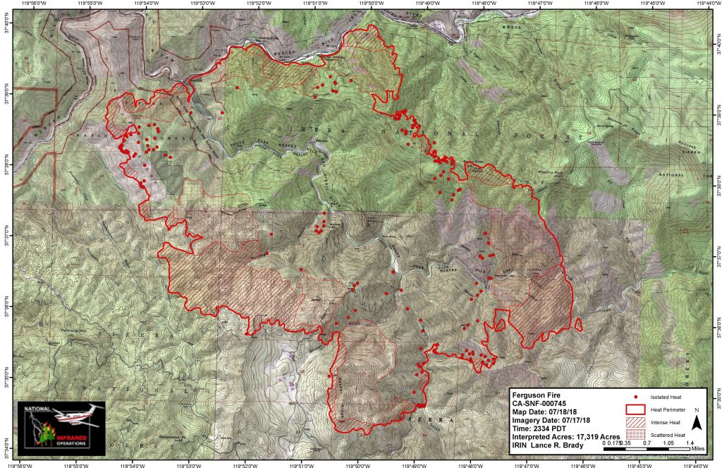
The Ferguson wildfires have been spreading in Mariposa County, California on the western edge of Yosemite National Park for days, burning 27 square miles and taking the life of one firefighter.

The Mercury News reported that more than 1,400 firefighters have been on the scene trying to protect 100 nearby homes and businesses that are in the fire’s path as it moves south and east.

The fires began July 13 at about 8:30 p.m. and by July 15 had nearly doubled to 9,300 acres. On Wednesday it was at 17,319 acres and 5% contained. And while authorities have not declared an official cause, Colin Gannon, senior data analyst at Four Twenty Seven, which studies the economic risk of climate change, said weather and environmental conditions are certainly contributing factors.

“In [this case], three factors—persistent wind, low humidity, and high availability of fuel sources—aligned just right for rapid fire growth. Weather conditions in the days leading up to the fire were extremely hot and dry, with temperatures approaching 100°F, and strong winds pushed the fire into the hills and valleys, allowing the it to spread quickly,” Gannon said. “Compounding this issue is the widespread presence of dry needles and dead trees, which are a highly combustible fuel source. To make matters worse, the location of the fire in steep and rugged terrain has made access difficult for those fighting the fire.”

On July 15, Pacific Gas & Electric Co. switched off power lines serving the area, affecting parts of Yosemite, El Portal and Foresta, in an effort to mitigate further fire risk.

The severity of the fires has not closed down Yosemite, which is nearly 1,200 square miles wide, but did force the closure of several miles of Highway 140 in Mariposa County west of El Portal, limiting some access to the park. The park’s website also advises visitors to “expect poor air quality and limited visibility due to the Ferguson Fire. Smoke may be heavy at times, and visitors should be prepared to limit any heavy outdoor activity during the periods of poor air quality.”

Weather is expected to remain hot and dry for the next seven days, with isolated thunderstorms possible over the Sierra Crest, which authorities are hoping could provide some relief.

According to the California Department of Forestry and Fire Protection, 3,213 fires burned 98,169 acres in the state between January 1 and July 15 of this year. That acreage is down more than 30,000 from this time last year. By September 2017, the Forest Service and Interior Department had spent more than $2 billion fighting fires in the United States for the year — making it the most expensive wildfire season on record.

The insurance industry has been reacting to the high activity, Gannon said, particularly regarding residential properties in risky areas.

“There have been incidents of private insurers dropping coverage for homeowners in high fire risk areas,” Gannon said. “It is difficult to say how pervasively this will occur when new science, and subsequently new understanding of fire risk, becomes available. As a result, state insurance, otherwise known as the California FAIR plan is stepping in to provide coverage for high risk areas.”

As Risk Management Monitor reported, the Insurance Institute for Business and Home Safety (IIBHS) recommends that organizations survey the materials and design features of their structures; as well as the types of plants used, their location and maintenance.

Companies also should determine their fire hazard severity zone (FHSZ) by evaluating the landscape, fire history in the area and terrain features such as slope of the land. Organizations can request the FHSZ rating from local building or fire officials in their area.

IIBHS notes three sources of wildfire ignition:

  1. Burning embers, or firebrands, generated by a wildfire and made worse in windy conditions.
  2. Direct flame contact from the wildfire.
  3. Radiant heat emanating from the fire.